
Why Does Every Everest Trekker Stop in Pheriche?
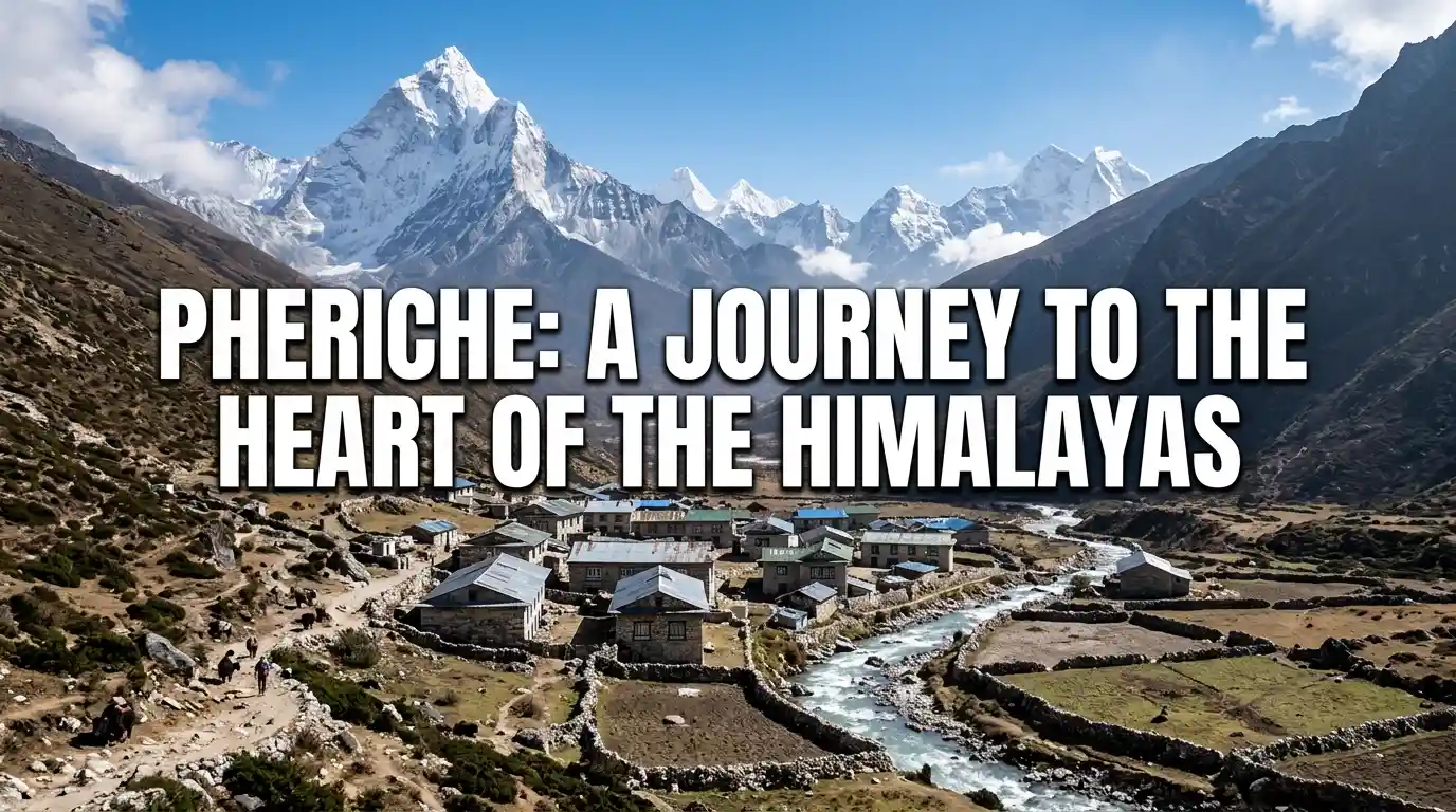
If you’ve looked at any Everest Base Camp itinerary, you’ve probably noticed the same village name popping up twice, once on the way up, once on the way down. So what’s actually going on in Pheriche that makes it so important?
In this blog, we’ll cover everything worth knowing about Pheriche: where it sits on the Everest Base Camp Trek, its altitude, the famous rescue clinic that’s saved more lives than most trekkers realize, the weather, how it compares to neighboring Dingboche, and what you can actually do there while your body catches up with the thin air.
Quick Facts: Pheriche at a Glance
| Attribute | Detail |
| Altitude | 4,371 m / 14,340 ft (upper village); 4,240 m / 13,910 ft (lower village) |
| Location | Khumbu region, Solukhumbu District, Sagarmatha National Park |
| River | Sits on the eastern bank of the Khumbu Khola |
| Nearest village | Dingboche, about 3-4 km / 30-90 min walk away |
| Days from Lukla | 4 to 5 trekking days, including a rest day at Namche Bazaar |
| Known for | Himalayan Rescue Association (HRA) aid post, established 1973 |
| Best season | Spring (Mar-May) and autumn (late Sep-Nov) |
Where Is Pheriche Located?
Pheriche is a small Sherpa settlement in the Khumbu region of Nepal’s Solukhumbu District, sitting inside Sagarmatha National Park. It’s tucked into a wide, flat glacial valley on the eastern bank of the Khumbu Khola, with steep ridges rising on both sides. That layout is exactly why the wind there has such a reputation, since the valley acts like a funnel for cold air coming off the surrounding peaks.
The village lies directly on the classic Everest Base Camp trekking route, between Pangboche below and Lobuche above. It’s not a detour or a side trip; pretty much anyone walking to Base Camp on foot passes through it, usually twice. That’s part of what makes Pheriche worth understanding properly before you go, rather than treating it as just another dot on the map.
Because it sits at a meaningful altitude and is close to Dingboche, Pheriche also plays a role in how trekking companies plan acclimatization days. Some itineraries build in an extra night here specifically because of what the village offers medically, which we’ll get into further down.
Pheriche’s Place on the Everest Base Camp Trail
Coming from Namche Bazaar, trekkers usually pass through Tengboche and Pangboche before dropping into the valley where Pheriche sits. Above the village, the trail continues to Thukla, then Lobuche, and eventually Gorak Shep and Base Camp itself. Each of these stops gains a bit more altitude, so Pheriche marks a fairly clear halfway point in terms of elevation gained on the trail.
On the way back down, a lot of itineraries route trekkers through Pheriche again rather than Dingboche, since it’s a slightly shorter and quieter descent. So don’t be surprised if your guide mentions the village twice on your trip plan; that’s completely normal and, if anything, a sign your itinerary is following a sensible acclimatization pattern.
How Far Is Pheriche From Lukla and Namche Bazaar?
Most itineraries take four to five trekking days to reach Pheriche from Lukla, gaining altitude gradually with a built in rest day at Namche Bazaar along the way. The pace is intentionally unhurried, steady rather than steep, because rushing this stretch is one of the more common ways trekkers end up with altitude sickness before they’ve even reached the interesting part of the trek.
Pheriche’s closest neighbor, Dingboche, is only about 3 to 4 kilometers away, roughly a 30 to 90 minute walk depending on your pace and the weather. The two villages get compared constantly, largely because they’re so close together yet feel so different day to day, which is a topic we’ll cover in more detail later in this guide.
What Is the Altitude of Pheriche?
Pheriche sits at roughly 4,371 meters, or 14,340 feet, above sea level. That’s the figure you’ll see most often, and it puts the village solidly into high altitude territory, well above where most people start noticing shorter breath and heavier legs on a normal walk. At this height, the amount of oxygen in the air is noticeably lower than at sea level, which is why even simple tasks like putting on boots can leave you slightly winded.
For context, that’s higher than nearly every peak in the European Alps, and Everest Base Camp itself is still about 1,000 meters above where you’ll be standing in Pheriche. Understanding this scale helps explain why the village functions less like a scenic stop and more like a working checkpoint on the way to something much higher.
Altitude alone doesn’t tell the whole story either. How your body responds depends on your pace, hydration, and how well you’ve acclimatized on the days leading up to Pheriche, not just the number on the map.
Why Do You See Two Different Altitude Figures for Pheriche?
If you’ve searched around, you may have noticed the altitude quoted differently, sometimes 4,371 meters, sometimes closer to 4,240 meters. Both numbers are correct, just for different parts of the village.
Pheriche isn’t a single point on the map. It spreads along a gently sloping valley floor, so:
- The lower lodges sit closer to 4,240 meters, or 13,910 feet
- The upper end of the village reaches around 4,371 meters, or 14,340 feet
Depending on which teahouse you end up sleeping in, your exact elevation for the night can shift by over a hundred meters, which is a small but real difference at this altitude.
Why Do Trekkers Stop in Pheriche?
The short answer is acclimatization and safety. Pheriche is one of the last major stops before the trail pushes into genuinely serious altitude, and it happens to be home to one of the most useful medical facilities anywhere on the Everest trekking route. That combination of location and infrastructure is rare on this trail, which is part of why the village carries so much weight in trip planning.
Trekkers spend time here mainly for two reasons: to let their bodies adjust before pressing on toward Lobuche and Base Camp, and because the village has resources, namely the clinic below, that simply don’t exist at the higher, more remote stops. Even trekkers who feel completely fine often stop here anyway, since the acclimatization benefit applies to everyone, not just those already showing symptoms.
The Himalayan Rescue Association Clinic
Pheriche is home to the Himalayan Rescue Association, or HRA, aid post, first set up in 1973 as little more than a rented yak herder’s hut. It’s since grown into a proper concrete facility, staffed seasonally by volunteer doctors during the spring and autumn trekking seasons, many of them experienced in mountain medicine from all over the world.
The clinic diagnoses and treats Acute Mountain Sickness, known as AMS, and watches for early warning signs of the far more dangerous High Altitude Pulmonary Edema and High Altitude Cerebral Edema. It also runs free daily lectures on altitude sickness, widely considered some of the best altitude education available anywhere in the Himalayas and an excellent resource on how to prevent AMS on EBC Trek, making them well worth attending even if you feel completely fine. The clinic treats trekkers, climbers, porters, and local Sherpa staff alike, since altitude doesn’t discriminate by job title.
Acclimatization Before Lobuche and Base Camp
Beyond the clinic, Pheriche functions as a checkpoint your body needs before the trail gets serious. Many itineraries schedule two nights here, or split between Pheriche and Dingboche, giving trekkers a day to hike a bit higher and sleep back down, the classic climb high, sleep low approach that helps the body build up red blood cells before the thinner air above.
Skipping this stage, or rushing through it, is one of the more preventable reasons trekkers end up turning back before Base Camp. Guides in the region generally treat this rest day as non negotiable, even when a group feels strong enough to push on faster.
What Is the Weather Like in Pheriche?
Even in the best trekking seasons, Pheriche runs cold. Daytime temperatures in peak season typically sit around 5 to 12 degrees Celsius, or 41 to 54 degrees Fahrenheit, while nights regularly drop well below freezing. The real defining feature, though, is the wind. The valley funnels a sharp, icy afternoon breeze down through the village that makes it feel noticeably colder than its altitude alone would suggest, and colder than neighboring Dingboche on most days.
Weather here can shift fast. Clear mornings are common, but afternoon cloud, snow flurries, and sudden temperature drops are all part of the package, even during the reliable spring and autumn windows. Packing layers you can add and remove quickly makes a real difference in comfort here.
Best Time to Visit Pheriche
Spring, from March to May, and autumn, from late September to November, are the two windows when most trekkers pass through, and for good reason. These are the seasons the HRA clinic itself is fully staffed, trails are clearer, and mountain views tend to be at their best. Winter is bitterly cold and quieter, while the summer monsoon brings rain, leeches lower down, and clouded in mountain views.
Pheriche or Dingboche, Which Should You Choose?
If your itinerary gives you a choice, going up favors Dingboche, and coming down favors Pheriche. Dingboche sits a little higher, catches more sun, and has more side hike options, which makes it a stronger acclimatization base before pushing on to Lobuche. Pheriche, being slightly lower and home to the HRA clinic, tends to suit the return leg better, especially if anyone in your group is feeling the effects of altitude.
Neither village is objectively better. The right choice really depends on where you are in the trek and what your body needs that day, and many trekkers end up spending a night in both anyway as part of a standard itinerary.
Key Differences Between the Two Villages
| Factor | Pheriche | Dingboche |
| Altitude | 4,371 m (14,340 ft) | 4,410 m (14,468 ft) |
| Weather | Colder, sharp valley wind | Sunnier, more sheltered |
| Facilities | Fewer teahouses | More teahouses & lodges |
| Medical care | HRA aid post on site | No clinic |
| Side hikes | Nangkartshang ridge, Everest Memorial | Nangkartshang Peak, Chhukung Ri |
| Best used | On the way down | On the way up |
What Is There to Do in Pheriche?
Beyond simply resting, Pheriche has a couple of worthwhile ways to spend an acclimatization day rather than just sitting in a teahouse. These options are gentle enough to support acclimatization without draining the energy you’ll need for the days ahead.
Nangkartshang Hike
A popular half day hike climbs the ridge behind the village, gaining around 700 meters before topping out with views of Ama Dablam, Island Peak, and the surrounding Khumbu peaks. It usually takes 3 to 4 hours up and 1 to 2 hours back down, a solid way to trigger acclimatization without wearing yourself out before the harder days ahead.
Everest Memorial and the Chukung Valley
Nearby, a memorial site carries the names of climbers who lost their lives attempting Everest, a quiet, sobering stop that a lot of trekkers say puts the scale of the mountain into perspective. For those with more time, the longer trail toward Chukung follows the Imja Khola valley through yak pastures, with teahouses along the way and views of Island Peak and Ama Dablam that are hard to beat.
Where Can You Stay and Eat in Pheriche?
Teahouses and Lodges
Pheriche has a modest but functional set of teahouses offering basic rooms, hot meals, and usually a wood or dung fired stove in the communal dining area, which, at this altitude, becomes the social heart of the evening. Don’t expect luxury; expect warmth, simple food, and other trekkers swapping stories about the trail ahead.
Food and Costs
Menus lean toward the usual Everest region staples: dal bhat, noodle soups, garlic soup, widely believed among trekkers to help with acclimatization, and hot drinks. Prices climb the higher you go, since everything is carried in by porter or yak, so don’t expect Kathmandu prices this high up the valley.
Conclusion
Pheriche isn’t a headline stop on most people’s Everest Base Camp bucket list. Nobody flies to Nepal dreaming of a windy valley at 4,371 meters. But it quietly does more for your trek’s success than almost any other village on the route, between the acclimatization time and the HRA clinic sitting right there if things go sideways.
If there’s one takeaway, it’s this: don’t rush through Pheriche just because it isn’t the exciting stop. Attend the altitude talk if you can, take the acclimatization day seriously, and let your body do the slow, unglamorous work it needs to do before the final push toward Base Camp.
How high is Pheriche?
Pheriche sits at roughly 4,371 meters (14,340 feet), though the lower end of the village is closer to 4,240 meters.
Is Pheriche colder than Dingboche?
Yes. Pheriche gets a sharp valley wind that makes it feel colder than nearby Dingboche, even at similar altitude.
How many days does it take to reach Pheriche from Lukla?
Most itineraries take four to five days, including a rest day in Namche Bazaar along the way.
What is the HRA clinic in Pheriche?
It’s a Himalayan Rescue Association aid post treating altitude sickness, running daily lectures since 1973.
Should I stay in Pheriche or Dingboche?
Dingboche suits the climb up; Pheriche, with its clinic, often works better on the way down.
What can I do in Pheriche besides rest?
Hike toward Nangkartshang Peak, visit the Everest Memorial, or walk the longer trail to Chukung.
What’s the best time to visit Pheriche?
Spring (March-May) and autumn (late September-November) offer the clearest trails and best mountain views.
Is there Wi-Fi or hot showers in Pheriche?
Some teahouses offer basic Wi-Fi and hot showers for a fee, but service is limited and not guaranteed.

Ready for your next Himalayan adventure?
Plan Your Next Big Adventure with Us
Explore Our AdventuresJoin our expert-guided journeys across Nepal and beyond, from classic trails to epic summits.