
Dingboche: Guide to Altitude, Weather, Distance & Trekking Routes
Are you planning an Everest adventure and wondering why every itinerary includes a mandatory stop in a scenic, stone-walled village? Dingboche is one of the most vital landmarks in the Khumbu region, serving as the ultimate gateway for those pushing toward the world’s highest peaks. This high-altitude settlement is more than just a place to sleep; it is a critical hub where trekkers prepare their bodies for the thin air of the upper Himalayas. Understanding the unique logistics of this village is the key to a safe and successful journey to Everest Base Camp or Island Peak.
In this blog, we provide a comprehensive guide to Dingboche, covering everything from its exact elevation to the seasonal weather patterns you can expect in 2026. We will detail the distances from major trekking hubs like Namche Bazaar and Tengboche, ensuring your daily planning is accurate and realistic. Additionally, we will explore the best acclimatization routes and side trips available from the village to maximize your chances of reaching your final goal. Whether you are a solo traveler or joining a group, this guide will help you navigate this essential Sherpa settlement within the protected boundaries of sagarmatha national park.
Where Is Dingboche Located?
Dingboche is located in the Imja Valley within the Khumbu region of northeastern Nepal, sitting at an elevation of 4,410 meters. It is situated northeast of Namche Bazaar and directly east of Pheriche, nestled at the foot of the massive Ama Dablam and Lhotse peaks. The village is part of the Sagarmatha National Park, a UNESCO World Heritage site, and serves as a major gateway for treks toward Everest and Island Peak. Its geographic position in a wide, sun-drenched valley makes it one of the most picturesque and strategic settlements in the high Himalayas.
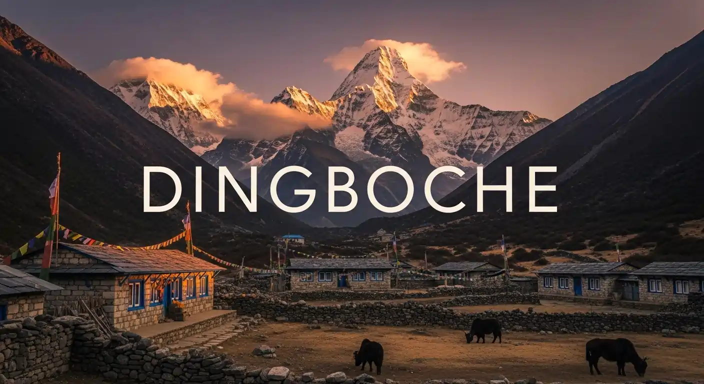
Dingboche Village in the Everest Region
Geographically, Dingboche lies on the banks of the Imja Khola, surrounded by some of the tallest peaks on Earth. It is famously known as the “summer valley” of the Khumbu because its wide landscape receives more sunlight than the shaded valley of Pheriche. Nearby settlements include the lower village of Pangboche and the higher summer grazing pastures of Bibre and Chhukung. As the last permanent Sherpa settlement in the upper Khumbu, it remains a vital hub for yak herding, agriculture, and high-altitude tourism.
Dingboche on the Everest Base Camp Trek Route
On the classic Everest Base Camp route, Dingboche is the traditional second acclimatization stop after Namche Bazaar. It is chosen over nearby Pheriche by most agencies because its slightly higher elevation and open terrain provide a better physiological challenge for trekkers. While Pheriche is often used on the return journey due to its lower altitude and medical post, Dingboche is the preferred “upward” stop to ensure success at higher camps. Spending two nights here allows your body to reach the critical red blood cell count needed for the final push to Lobuche and Gorakshep.
Dingboche Altitude, Elevation & Height
Dingboche sits at an altitude of 4,410 meters (14,468 feet), placing it firmly within the high-altitude zone where oxygen levels are significantly lower than at sea level. This specific elevation is critical because it marks the threshold where many trekkers begin to feel the early effects of the thin air. Reaching this height is a major milestone in any Everest region trek, as it signifies you have surpassed the tree line and entered the alpine tundra. Managing your pace at this altitude is essential to avoid altitude sickness and ensure your body adapts correctly for the even higher stages ahead.
Dingboche Altitude Explained
The 4,410-meter altitude of Dingboche matters because it is the point where atmospheric pressure drops to approximately 58% of sea-level pressure. For trekkers, this means every breath contains significantly fewer oxygen molecules, forcing the heart and lungs to work much harder even while at rest. This elevation is the primary reason why a two-night acclimatization stay is mandatory for most commercial itineraries. Without this physiological adjustment, the risk of developing high-altitude pulmonary or cerebral edema increases drastically as you move toward the 5,000-meter mark.
Dingboche Elevation vs Height
In a trekking context, the elevation of Dingboche refers to its fixed vertical distance above mean sea level, whereas height often describes the vertical distance of a specific peak or point above its immediate base. As you gain elevation from Tengboche to Dingboche, the air density decreases linearly, which directly impacts your physical stamina and cognitive function. This gain in elevation is what triggers the body’s natural acclimatization process, such as the production of more red blood cells to carry limited oxygen. Understanding this difference helps trekkers appreciate the steady vertical progress they make toward the base of the world’s highest mountains.
Dingboche Weather and Temperature Throughout the Year
The weather in Dingboche is characterized by a harsh alpine climate where temperatures frequently drop below freezing even during the daytime in winter. Because of its high altitude, the village experiences extreme diurnal temperature shifts, meaning you might enjoy a warm, sunny afternoon followed by a bone-chilling night. Wind is also a major factor in the Imja Valley, with gusty conditions often making the air feel much colder than the actual thermometer reading.
Dingboche Weather Overview
Dingboche sits in a wide, sun-exposed valley, which makes it feel significantly warmer and more pleasant during the day compared to the nearby, wind-swept village of Pheriche. However, the weather remains typical of the high Himalayas, with thin air and intense UV radiation that can lead to rapid sunburn if you are not careful. Weather conditions can change in minutes, shifting from crystal-clear blue skies to thick fog or sudden light snowfall even during the peak months. This variability is exactly why the village is used for acclimatization; it tests your gear and your body’s ability to handle the changing alpine environment.
Dingboche Temperature by Season
Temperatures in Dingboche fluctuate wildly, with spring and autumn seeing daytime highs of 10°C to 15°C and night lows dropping between -5°C and -10°C. During the winter months of December to February, the environment becomes truly extreme, as nighttime temperatures can plummet to -20°C or even lower. The monsoon season (June to August) is milder, with daytime temperatures hovering around 15°C, but high humidity and constant cloud cover make it feel damp and chilly. Regardless of the month, you should always expect temperatures to be well below zero once the sun dips behind the towering peaks of Ama Dablam and Lhotse.
Best Time to Visit Dingboche
The absolute best time to visit Dingboche is during the autumn months of October and November, when the monsoon rains have cleared the dust, leaving behind exceptionally sharp mountain visibility. Spring (March to May) is the second-best window, offering slightly warmer daytime temperatures and the beautiful sight of blooming rhododendrons in the lower valleys before you reach the village. These “peak” seasons provide the most stable weather, ensuring your acclimatization hikes are safe and your views of Everest and Island Peak are unobstructed. While trekking is possible in winter, it requires specialized cold-weather gear and a high tolerance for sub-zero living conditions.
Tengboche to Dingboche Distance and Trekking Route
The trekking distance from Tengboche to Dingboche is approximately 10.5 kilometers (6.5 miles) and typically takes 5 to 6 hours to complete. While the trail starts with a pleasant descent through rhododendron and birch forests, the majority of the route involves a steady, gradual incline as you gain about 550 meters of elevation. Most trekkers stop for lunch in the village of Shomare or Pangboche to fuel up before the final stretch into the Imja Valley. This section is vital for your journey, as it marks your transition from the lush forest zones into the high-altitude alpine tundra.
Tengboche to Dingboche Distance
The 10.5-kilometer journey is considered a moderate day of trekking because the elevation gain is spread across several hours of walking. You will spend about 2 hours reaching the village of Pangboche and another 3 to 4 hours navigating the higher, more barren landscape toward Dingboche. Because the air becomes noticeably thinner above 4,000 meters, your walking pace will naturally slow down regardless of the actual distance. Most itineraries schedule this move as Day 5 or 6 of the Everest Base Camp trek to ensure a safe and progressive climb.
Tengboche to Dingboche Trail Experience
The trail begins with a descent to Deboche before crossing a scenic suspension bridge over the rushing Imja Khola river. As you climb toward Pangboche, the forest thins out, replaced by rugged, rocky terrain and expansive views of the towering Ama Dablam. You will pass through traditional Sherpa farmlands enclosed by ancient stone walls, which protect local crops from the high-altitude winds. The final stretch into Dingboche is a gradual wind-up through the wide Imja Valley, offering a sense of scale and grandeur that is unique to this part of the Khumbu.
Dingboche to Lobuche Distance and Route Details
The trekking distance from Dingboche to Lobuche is approximately 8 to 9 kilometers (5 to 5.6 miles) and takes 5 to 6 hours to complete. Although the distance is shorter than previous days, you will gain roughly 500 meters of elevation, bringing you to an altitude of 4,910 meters. The journey involves a gentle climb across the Pheriche valley plateau before a steep, challenging ascent up the Thukla Pass. This stage is a critical transition as you leave the last signs of vegetation behind and enter the rugged glacial moraine of the high Himalayas.
Dingboche to Lobuche Distance
Most trekkers cover the 8-kilometer stretch at a slow and steady pace to manage the increasingly thin air and significant elevation gain. The first half of the trek to the small settlement of Thukla is a gradual incline that takes about 2 to 3 hours of walking. After a lunch break, the final push involves a steep 45-minute climb to the top of the Thukla Pass followed by a 1.5-hour gentle walk to Lobuche. Because you are pushing toward the 5,000-meter mark, this relatively short distance feels much more strenuous than longer days at lower altitudes.
What to Expect on the Dingboche to Lobuche Trek
The landscape transforms into barren, moon-like terrain as you walk alongside the massive lateral moraine of the Khumbu Glacier. One of the most emotional highlights of the route is the memorial site at the top of Thukla Pass, which features stone monuments dedicated to fallen climbers and Sherpas. You should expect colder, windier conditions and a significant drop in oxygen levels, which can cause slower movement and frequent breathlessness. Despite the physical challenge, the panoramic views of peaks like Pumori, Nuptse, and Lobuche East are some of the most spectacular on the entire Everest Base Camp trek.
How Is the Weather in Dingboche for Trekkers?
The weather in Dingboche is notoriously cold and unpredictable, with daytime temperatures ranging from 10°C to 15°C and nighttime temperatures often dropping well below freezing. Because the village is located in a wide, high-altitude valley, it is highly susceptible to biting winds that can make the “real feel” temperature significantly lower. In the mornings, you can expect frost-covered trails and clear skies, while afternoons often bring a layer of clouds and mist. Trekkers must be prepared for extreme temperature swings and have reliable gear to handle the sub-zero conditions that are common after sunset.
Weather Challenges at Dingboche Altitude
The primary weather challenges in Dingboche are the intense morning cold and the powerful afternoon winds that sweep through the Imja Valley. Because the village sits above the tree line at 4,410 meters, there is no natural protection from the elements, leaving trekkers exposed to harsh UV rays and freezing drafts. Sudden changes are common; a sunny morning can quickly transition into a snow-dusted afternoon or thick fog that reduces visibility on acclimatization trails. These rapid shifts require constant vigilance and the ability to adjust your layers and pace to avoid both hypothermia and heat exhaustion.
Tips to Handle Dingboche Weather Safely
To handle the Dingboche weather safely, you should use a high-performance three-layer clothing system consisting of a base layer, an insulating mid-layer, and a windproof outer shell. It is essential to start your daily treks or acclimatization hikes early in the morning to take advantage of the calmer, clearer weather before the afternoon winds pick up. Always keep a warm beanie and a pair of gloves in your daypack, even if it feels warm when you leave your teahouse. Additionally, staying properly hydrated and wearing high-SPF sunscreen will help your body manage the physical stress caused by the dry, thin air and intense mountain sun.
Accommodation and Facilities in Dingboche
Accommodation in Dingboche is well-developed, offering a variety of teahouses that range from basic wooden lodges to more comfortable hotels with modern amenities. Most lodges provide simple twin-sharing rooms with shared bathrooms, though an increasing number of establishments now offer private rooms with en-suite facilities and even electric blankets. Because Dingboche is a primary acclimatization hub, the lodges are designed to be social spaces where trekkers can relax in heated dining halls and share stories. In 2026, it remains one of the most comfortable high-altitude stops in the Khumbu, providing essential recovery before you push toward the 5,000-meter mark.
Teahouses and Lodges in Dingboche
Teahouses in Dingboche vary in comfort, but all provide the essential warmth and shelter needed for a multi-night stay at 4,410 meters.
- Basic Twin Rooms: Standard rooms usually feature two single beds with mattresses, pillows, and warm blankets, though a sleeping bag is still recommended.
- Luxury Options: Newer hotels like Dingboche Resort or Hotel Bright Star offer en-suite bathrooms and heated beds for a premium price.
- Communal Dining Halls: These are the heart of the teahouse, usually heated by a central pot-bellied stove burning dried yak dung or wood.
- Shared Facilities: Most budget-friendly lodges have common squat or Western-style toilets located at the end of the hallways.
- Hot Shower Services: Gas or solar-powered showers are available for an extra fee, typically ranging from NPR 600 to 1,000 per session.
- Booking in Peak Season: Because it is a mandatory stop, popular lodges fill up quickly in October and April, so advance booking is highly advised.
Food, Water, and Internet Availability
While remote, Dingboche offers a surprising variety of food and digital connectivity to keep trekkers fueled and in touch with home.
- Diverse Menus: You can find everything from traditional Dal Bhat and Sherpa stew to international dishes like pasta, pizza, and apple pie.
- Safe Drinking Water: Bottled water is available but expensive; most trekkers use purification tablets or filtered water provided by lodges for a small fee.
- Everest Link WiFi: This is the most reliable internet option, with prepaid cards providing volume-based data that works throughout the village.
- Cellular Network: NTC and Ncell signals are patchy and often disappear completely as you move toward the higher Imja Valley.
- Charging Stations: Expect to pay an hourly fee of NPR 300 to 500 to charge phones, while power banks usually cost more due to their higher capacity.
- Bakeries and Cafes: Dingboche is famous for its high-altitude bakeries, like Cafe 4410, where you can enjoy fresh coffee and pastries with mountain views.
Why Is Dingboche Important for Acclimatization?
Dingboche is crucial for acclimatization because its elevation of 4,410 meters provides the perfect “goldilocks” altitude for the body to adapt before surpassing 5,000 meters. Staying here for two nights allows your blood oxygen saturation levels to stabilize and triggers the production of more red blood cells, which is vital for the upcoming climb to Everest Base Camp. This village acts as a physiological buffer zone where the air is thin enough to challenge your system but thick enough to allow for rest and recovery. Skipping this step significantly increases the risk of severe altitude sickness as you move toward the harsher conditions of Lobuche and Gorakshep.
Acclimatization Day in Dingboche
The most popular acclimatization activity in Dingboche is the hike to Nangkartshang Peak (5,083m), which follows the “climb high, sleep low” philosophy to strengthen your cardiovascular system. This steep trek takes 3 to 4 hours and offers breathtaking views of Makalu, Lhotse, and Ama Dablam, serving as a vital training ground for the higher sections of the trek. Alternatively, you can take a more gradual walk toward the village of Chhukung in the Imja Valley to experience the glacial scenery without extreme vertical gain. Regardless of your choice, staying active during the day while returning to the lower village to sleep is the gold standard for safe high-altitude progression.
Common Altitude Symptoms at Dingboche
At 4,410 meters, it is normal to experience mild symptoms like slight breathlessness, a light headache, or difficulty sleeping as your body adjusts to the lack of oxygen. However, you must remain vigilant for “red flag” signs such as a persistent, throbbing headache that doesn’t respond to medication, severe nausea, or a total loss of appetite. If you experience extreme fatigue, a rattling cough, or a lack of coordination (ataxia), these are serious indicators that you should not ascend any further. In these cases, the safest course of action is an immediate descent to a lower elevation like Pangboche or Namche Bazaar to seek medical attention and allow your body to recover.
Things to Do During Acclimatization in Dingboche
During your acclimatization stay in Dingboche, you should focus on active recovery by engaging in short, high-altitude hikes and light physical activity. These movements help your heart and lungs adapt to the thinner air while preventing your muscles from becoming stiff during the rest day. The village offers a variety of routes that allow you to follow the “climb high, sleep low” principle while enjoying some of the best mountain scenery in the world. Taking advantage of these opportunities ensures your body is fully prepared for the 5,000-meter threshold that lies ahead in 2026.
Nangkartshang Peak Hike
Hiking Nangkartshang Peak is the most popular choice for trekkers, offering a steep 400-meter vertical climb that provides incredible views of Ama Dablam, Makalu, and Lhotse. The trail is well-defined and serves as a vital test for your lungs, helping you gauge how your body will perform at higher altitudes. Reaching the summit at 5,083 meters is a significant milestone that boosts both your physical acclimatization and your mental confidence for the trek ahead.
Exploring Dingboche Village
Exploring the village itself allows you to witness the traditional Sherpa way of life, from the ancient stone walls protecting buckwheat fields to the grazing yaks in the alpine meadows. You can spend your afternoon visiting the local high-altitude bakeries or capturing stunning photography of the village nestled beneath the towering, jagged peaks of the Imja Valley. The golden hour in Dingboche is particularly magical, providing a perfect backdrop for landscape photography as the sun sets over the surrounding 6,000-meter summits.
Essential Tips for Staying in Dingboche
Success in Dingboche relies on meticulous preparation for extreme cold and a disciplined approach to high-altitude safety. Because the village sits at a critical threshold of 4,410 meters, your body is under constant physiological stress, making rest and proper gear non-negotiable. It is essential to treat your two-night stay here with respect by following local health advice and staying vigilant about your physical condition. These small, daily habits are what ultimately determine whether you successfully cross the 5,000-meter mark or are forced to descend.
What to Pack for Dingboche
Your packing list for Dingboche must prioritize heavy-duty insulation and specialized items to protect you from the thin, freezing mountain air.
- Heavyweight Down Jacket: A high-fill-power jacket is mandatory for the sub-zero evenings when the sun disappears behind the peaks.
- -15°C Rated Sleeping Bag: Teahouse blankets are insufficient for the unheated rooms at this altitude; a personal winter bag is a survival necessity.
- Thermal Base Layers: Pack at least two sets of merino wool thermals to wick moisture during the day and keep you warm at night.
- High-SPF Sunscreen and Lip Balm: The UV radiation at 4,410m is incredibly intense and can cause severe burns in less than an hour of exposure.
- Portable Power Bank: Batteries drain rapidly in the cold; carry a 20,000mAh bank to keep your phone and headlamp charged.
- Hydration Bladder and Tablets: Staying hydrated is your best defense against AMS, so carry a 3-liter bladder and water purification tablets.
Safety Tips at Dingboche Elevation
Staying safe at 4,410 meters requires a “slow and steady” mindset and a proactive attitude toward monitoring your health and the environment.
- Aggressive Hydration: Aim to drink 4 to 5 liters of water daily, even if you don’t feel thirsty, to combat the dehydrating effects of high altitude.
- Climb High, Sleep Low: Use your acclimatization day to hike to Nangkartshang Peak (5,083m) before returning to the lower village of Dingboche to sleep.
- Pace Yourself: Walk at a conversational pace; if you are too breathless to speak, you are moving too fast for your body to acclimatize.
- Avoid Alcohol and Tobacco: These substances depress your breathing and dehydrate your system, significantly increasing the risk of altitude sickness.
- Monitor AMS Symptoms: If you develop a persistent headache, nausea, or loss of appetite, inform your guide immediately and do not ascend further.
- Check the Oximeter: Use a pulse oximeter daily to track your oxygen saturation levels and ensure your body is successfully adapting to the thin air.
Dingboche vs Other Acclimatization Stops
Dingboche offers a unique high-altitude experience that differs significantly from lower hubs like Namche Bazaar or neighboring villages like Pheriche. While lower stops focus on initial adaptation to the thinning air, Dingboche provides the final, critical physiological bridge before you enter the extreme environments above 5,000 meters. The choice of where you spend your rest days can impact your energy levels and your body’s ability to handle the final push to Everest Base Camp. Understanding these differences allows you to choose the best route for your physical needs and comfort in 2026.
Dingboche vs Namche Bazaar
Namche Bazaar (3,440m) is the first major acclimatization hub where you transition from “low” to “high” altitude amidst bustling markets and modern cafes. In contrast, Dingboche (4,410m) is nearly 1,000 meters higher and sits above the tree line, offering a much colder, more rugged, and quieter alpine atmosphere. While Namche focuses on getting your body ready for the high Khumbu, Dingboche is about the final red blood cell production needed for the sub-zero summits.
Dingboche vs Pheriche
Dingboche and Pheriche are located in parallel valleys, but Dingboche is generally preferred for acclimatization because its sunny, wide Imja Valley is warmer and more pleasant than the wind-swept Pheriche floor. Pheriche sits slightly lower and is home to the Himalayan Rescue Association (HRA) medical post, making it a common stop on the way down for those seeking treatment. However, the superior views of Ama Dablam and the better hiking trails like Nangkartshang make Dingboche the gold standard for the upward journey.
Final Thoughts on Dingboche
Understanding the unique altitude, weather, and distance logistics of Dingboche is the foundation for a safe and successful Everest region trek in 2026. This iconic Sherpa village serves as much more than a scenic stop; it is a critical physiological bridge that prepares your body for the extreme conditions above 5,000 meters. By respecting the mandatory acclimatization period and utilizing the local trails for active recovery, you significantly increase your chances of reaching Everest Base Camp or Island Peak. Proper preparation ensures that your time in this “summer valley” is both productive and memorable.
Choosing an expert partner like Marvel Treks ensures your stay in Dingboche is optimized with the best local lodges and professional guidance. Our veteran Sherpa guides monitor your health closely and lead the most effective acclimatization hikes to Nangkartshang Peak to guarantee your safety. We handle all the complex logistics, from permits to high-altitude nutrition, so you can focus entirely on the stunning Himalayan panoramas. Let us help you turn your high-altitude dreams into a reality with the personalized care and expertise that only a local leader can provide.
Ready to experience the magic of the Imja Valley with Nepal’s leading trekking experts? Contact the best trekking and expedition company in Nepal today to book your 2026 Everest Base Camp adventure and secure the best lodges in Dingboche!
FAQs: Dingboche Trekking Guide
What is the exact altitude of Dingboche village?
Dingboche is located at an elevation of 4,410 meters (14,470 feet), making it a key high-altitude hub.
Why do trekkers stay two nights in Dingboche?
Staying two nights allows the body to produce extra red blood cells, which is essential for safe acclimatization.
How cold does it get in Dingboche at night?
During peak seasons, nighttime temperatures regularly drop between -5°C and -15°C, requiring high-quality thermal gear and sleeping bags.
Is there internet or WiFi available in Dingboche?
Yes, most lodges offer Everest Link WiFi for a fee, though the signal can be spotty during bad weather.
What is the best acclimatization hike from Dingboche?
The hike to Nangkartshang Peak (5,083m) is the gold standard for “climbing high and sleeping low” in the village.
Can I see Mt. Everest from Dingboche village?
While Everest is hidden by the Nuptse-Lhotse ridge, you get world-class views of Ama Dablam, Lhotse, and Island Peak.
What is the distance from Tengboche to Dingboche?
The trek covers approximately 10.5 kilometers and takes about 5 to 6 hours of steady walking to complete.
Are there medical facilities available in Dingboche?
There are basic health clinics in the village, but the main Himalayan Rescue Association post is in nearby Pheriche.
Ready for your next Himalayan adventure?
Plan Your Next Big Adventure with Us
Explore Our AdventuresJoin our expert-guided journeys across Nepal and beyond, from classic trails to epic summits.