
Langtang Lirung: Everything You Need To Know
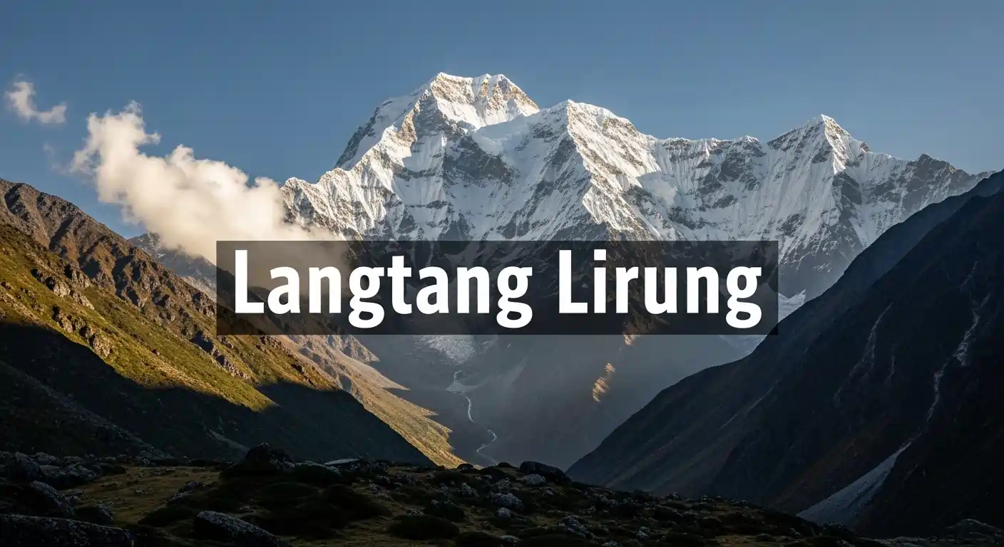
Dominating the skyline north of Kathmandu, Langtang Lirung stands as the highest peak of the Langtang Himal range, reaching an imposing elevation of 7,227 meters. While it is often overshadowed by the 8,000-meter giants, this mountain is a formidable technical challenge that commands respect from the world’s most elite alpinists. For trekkers in the Langtang Valley, it serves as a breathtaking backdrop, but for climbers, it represents one of the most complex and statistically demanding peaks in the Central Himalayas.
At Marvel Treks, we believe that understanding the geography and history of this peak is essential for anyone visiting the Rasuwa district. This guide provides a deep dive into the technicalities, viewing points, and the resilient spirit of the region surrounding the “Great White Peak,” serving as a vital resource for those preparing for a Langtang Lirung expedition.
Where Is Langtang Lirung Located?
Langtang Lirung is located in the Rasuwa District of Nepal, approximately 60 kilometers north of Kathmandu, serving as the highest peak of the Central Himalayan range. It forms a massive physical barrier between the Langtang Valley and the Tibet Autonomous Region, with its southern slopes descending sharply into one of Nepal’s most popular trekking destinations, providing the iconic backdrop for every langtang valley trek.
Overview of Langtang Lirung Nepal
This majestic peak is the undisputed monarch of the Langtang Himal, a subrange of the Himalayas that sits nestled between the Ganesh Himal to the west and the Jugal Himal to the east. Reaching an elevation of 7,227 meters, it is a prominent feature for anyone trekking through the central hills of Nepal, often recognizable by its steep, icy south face that reflects the morning sun. Its presence defines the local climate and geography, acting as a primary source for the glacial systems that feed the Trisuli River downstream.
Location within Langtang National Park
The mountain serves as the dramatic centerpiece of Langtang National Park, Nepal’s first Himalayan national park established in 1976 to protect the region’s unique flora and fauna. It is surrounded by high-altitude alpine meadows and dense forests of rhododendron and bamboo, which provide a sanctuary for the endangered red panda and snow leopard. The park’s boundaries wrap around the base of the massif, ensuring that the trek toward the mountain remains one of the most pristine wilderness experiences in the country, free from heavy industrial development.
Proximity to Kathmandu
One of the most remarkable aspects of Langtang Lirung is its accessibility, as it is the closest high Himalayan peak to the capital city of Kathmandu. On clear days, the mountain’s white pyramid is visible from the rim of the Kathmandu Valley, specifically from vantage points like Shivapuri or Nagarkot, making it a constant sentinel over the urban landscape. For adventurers, this proximity means you can reach the trailhead at Syabrubesi in a single day’s drive, allowing for a rapid transition from the bustling city to the heart of the high Himalayas.
Border Geography near Tibet
Langtang Lirung sits just south of the international border between Nepal and Tibet, forming part of a complex mountain wall that separates the two regions. While the summit itself is entirely within Nepalese territory, its northern ridges extend toward the Tibetan plateau, creating a dramatic climatic divide between the humid southern valleys and the arid rain shadow to the north. This border geography has historically influenced the local culture, as the high passes surrounding the mountain served as ancient trade routes for salt and wool between the two nations for centuries.
Langtang Lirung Height and Key Facts
Langtang Lirung stands at an impressive 7,227 meters (23,711 feet), making it the undisputed highest peak of the Langtang Himal range and a dominant feature of the Central Nepalese skyline. While it does not reach the 8,000-meter mark, its massive vertical relief and technical complexity make it one of the most respected and physically demanding mountains in the entire Himalayan chain, often discussed alongside the best mountains to climb in Nepal for those seeking a true alpine challenge.
- Elevation: The official height is recorded at 7,227 meters (23,711 feet), placing it firmly within the elite category of the world’s 7,000-meter peaks.
- Nepal Ranking: It is currently ranked as the 99th highest mountain in the world, but its prominence of 1,525 meters (5,003 feet) makes it appear much larger than many of its neighbors.
- First Successful Ascent: After many tragic attempts, the mountain was finally conquered on October 24, 1978, by a joint Japanese-Nepalese team consisting of Seishi Wada and Pemba Tsering.
- Mountain Classification: Classified as a technical Himalayan peak, it is known for high objective hazards, including frequent ice avalanches and complex glacier navigation.
- Parent Peak: Its geological parent peak is Shishapangma (8,027m), the only 8,000-meter peak located entirely within Tibet, situated just across the northern border.
- Cultural Significance: To the local Tamang and Tibetan-origin communities, the mountain is often viewed as a protective deity, anchoring the spiritual landscape of the Langtang Valley.
Why Is Langtang Lirung Famous Among Mountaineers?
Langtang Lirung is famous among elite mountaineers because it is widely considered one of the most technical and dangerous 7,000-meter peaks in the world, often presenting a higher objective risk than many 8,000-meter giants. Its reputation is built on a high “failure-to-summit” ratio, driven by complex glacial systems and a notorious frequency of ice avalanches that demand absolute precision in timing and route selection. For the global climbing community, a summit of Langtang Lirung is a definitive badge of technical mastery and psychological resilience.
Technical Difficulty
Unlike the popular “trekking peaks” found throughout Nepal, Langtang Lirung offers no easy walk-up route, requiring sustained Grade IV and V alpine climbing skills from Base Camp to the summit. Alpinists must navigate highly active icefalls and labyrinthine crevasse fields that shift significantly each season, making previous route knowledge almost obsolete. The mountain demands a high level of proficiency in both vertical ice and mixed tool work, as well as the ability to move quickly through “kill zones” where serac falls are a constant threat.
Dramatic Ridgelines
The mountain is defined by its aesthetic but terrifyingly sharp ridgelines, particularly the Southeast and Southwest ridges, which offer some of the most exposed climbing in the Central Himalayas. These “knife-edge” snow areas require perfect balance and focus, as they are often buffeted by high-velocity winds coming off the Tibetan Plateau. Navigating these narrow crests involves thousands of meters of vertical drop on either side, providing a level of “airiness” and exposure that attracts world-class climbers seeking a pure, high-stakes alpine experience.
Steep Ice and Rock Sections
The upper reaches of Langtang Lirung consist of near-vertical ice walls and brittle rock bands that make the final push to 7,227 meters a grueling mechanical challenge. Climbers often encounter “blue ice”, extremely hard, old ice that is difficult to protect with screws, interspersed with crumbling granite sections that require delicate mixed climbing. These sections are physically exhausting at high altitude, forcing teams to set up fixed lines and high camps on precarious ledges, adding to the overall technical complexity of the expedition.
Reputation as One of Nepal’s Challenging 7,000m Peaks
Among the professional climbing circuit, Langtang Lirung is respected as a “peak of consequence,” where the margin for error is nearly zero. It sits in a category of 7,000-meter peaks, alongside others like Annapurna III or Nuptse, that are sought after by those who prioritize technical difficulty and solitude over the crowded standard routes of the 8,000-meter peaks. This reputation has been cemented by the many legendary climbers who have been turned back by its defenses, making it a true connoisseur’s mountain in the world of high-altitude alpinism.
The East Face of Langtang Lirung: A Legendary Challenge
The East Face of Langtang Lirung is revered as one of the most formidable vertical walls in the Himalayas, rising nearly 3,000 meters from the glacier to the summit. It is a daunting arena of near-vertical ice and crumbling rock that has repelled all but the most elite alpinists, making it a legendary “last great problem” for high-altitude climbers. Success on this face requires a rare combination of extreme technical skill, speed, and the mental fortitude to endure constant objective hazards in total isolation, often leading veterans to describe it as the hardest mountain to climb in Nepal.
What Makes the Langtang Lirung East Face So Difficult?
The primary obstacle of the East Face is its immense vertical relief, which forces climbers into sustained, high-angle ice and mixed climbing for thousands of meters without significant ledge systems for protection or rest. This face is notorious for its highly active seracs and frequent avalanches that sweep across the narrow climbing lines, leaving no room for error in timing or route selection. Because the face is exposed to the first rays of the morning sun, the risk of rockfall and ice-melt increases rapidly after dawn, requiring teams to move with incredible speed in the freezing darkness. The combination of extreme steepness and the unpredictable nature of the Himalayan weather makes it a graveyard for many ambitious expeditions.
Tomaz Humar and the East Face of Langtang Lirung
The East Face is inextricably linked to the legendary Slovenian alpinist Tomaz Humar, whose 2009 solo attempt on the wall became one of the most poignant stories in modern climbing history. Humar, known for his audacious solo ascents on peaks like Dhaulagiri, was trapped high on the face after a fall and tragically perished before rescue teams could reach his extreme location. His attempt remains a testament to the “light and fast” alpine style, pushing the boundaries of what is possible for a lone climber on a 7,000-meter wall. Today, Humar’s legacy on Langtang Lirung serves as a somber reminder of the mountain’s power and the thin line between Himalayan triumph and tragedy.
Langtang Lirung Climbing Guide
Climbing Langtang Lirung is a serious undertaking that requires professional-grade logistics, an elite level of technical proficiency, and a deep understanding of Himalayan weather patterns. Unlike the commercialized routes of the 8,000-meter peaks, this mountain offers a raw, alpine-style experience where self-sufficiency and rapid decision-making are the keys to survival. At Marvel Treks, we emphasize that a successful expedition to this 7,227-meter peak is defined by meticulous preparation and a respect for the mountain’s notoriously high objective hazards.
Best Season for Langtang Lirung Climbing
The primary climbing windows are the pre-monsoon (Spring) and post-monsoon (Autumn) seasons, each offering distinct advantages and challenges. Spring (April–May) typically provides longer daylight hours and slightly warmer temperatures, though the risk of spring snow-storms and moisture-laden avalanches remains a major concern on the South Face. Autumn (September–October) is often preferred for its more stable, crystal-clear weather and firmer ice conditions, but the dropping temperatures and shorter days require teams to move with extreme efficiency. Regardless of the season, the “weather window” on Langtang Lirung is notoriously narrow, often requiring climbers to wait for weeks at Base Camp for a single 48-hour opening of calm winds.
Technical Difficulty Level
On the international mountaineering scale, Langtang Lirung is graded as an extremely difficult technical peak, demanding mastery of Grade IV/V ice and mixed climbing. Climbers must be comfortable navigating “knife-edge” snow areas with thousands of meters of exposure and vertical ice sections that require precise front-pointing in double or triple boots. It is not a mountain for high-altitude novices; successful candidates typically have several 6,000m technical peaks and significant alpine experience in ranges like the Alps or the Andes. The constant threat of serac falls and shifting glaciers means that “route finding” is a continuous, high-stakes mental challenge throughout the entire ascent.
Permits and Regulations
Navigating the legal requirements for a 7,000-meter peak in Nepal is a multi-step process that must be completed through a government-authorized trekking agency like Marvel Treks. You are required to obtain a Climbing Permit from the Department of Tourism (DoT), which includes the mandatory hiring of a government liaison officer to oversee the expedition’s environmental and safety compliance. Additionally, because the mountain is the centerpiece of a protected area, you must secure a Langtang National Park Entry Permit and a TIMS (Trekkers’ Information Management System) card. These regulations are strictly enforced to ensure the sustainability of the region and the safety of all climbers entering the high-altitude wilderness of the Rasuwa district.
How Difficult Is Langtang Lirung Compared to Other 7,000m Peaks?
Langtang Lirung is significantly more difficult than popular 7,000m peaks like Himlung Himal or Putha Hiunchuli, as it prioritizes extreme technical climbing over mere altitude. While many peaks in this height range are “walk-up” expeditions, Langtang Lirung requires elite-level ice climbing, navigation of active glaciers, and the management of constant objective hazards like serac falls.
| Feature | Langtang Lirung (7,227m) | Himlung Himal (7,126m) | Putha Hiunchuli (7,246m) |
| Technical Grade | Extremely High (Technical Alpine) | Moderate (Snow Slope) | Low to Moderate (Ski-able) |
| Primary Challenge | Vertical ice, rockfall, & avalanches. | Sustained cold & long ridges. | Long approach & altitude. |
| Climbing Style | Technical Ice/Mixed Climbing. | Fixed-rope trekking style. | Long snow trudging/Skiing. |
| Objective Risk | Very High (Active seracs). | Low (Stable slopes). | Low (Predictable terrain). |
| Success Rate | Low (Statistically demanding). | High (Popular commercial peak). | High (Great for first 7,000m). |
| Best For | Elite Alpinists / Professionals. | Advanced Trekkers/Climbers. | Aspiring 8,000m climbers. |
Langtang Lirung Base Camp Trek
The Langtang Lirung Base Camp Trek is a legendary journey into the heart of the Central Himalayas, offering a front-row seat to the massive hanging glaciers and vertical ice walls of the Langtang massif. This trek is widely considered one of the most rewarding in Nepal, combining rich Tamang culture with high-alpine scenery that culminates at the base of the “Great White Peak.” Unlike the crowded trails of Everest or Annapurna, this route provides a raw, intimate connection with the mountains, making it a favorite for those seeking a more authentic Himalayan wilderness experience.
Trekking Route to Langtang Lirung Base Camp
The journey begins with a scenic drive from Kathmandu to Syabrubesi, the bustling gateway to the Langtang Valley. From there, the trail climbs steadily through dense forests of oak and rhododendron, following the roaring Langtang Khola river through the narrow gorge of Lama Hotel and up to the wide, glacial U-shaped valley of Mundu and Kyanjin Gompa. The final push to the Base Camp (approx. 4,200m) takes you past the yak pastures of the upper valley, where the trees disappear and are replaced by the dramatic terminal moraine of the Lirung Glacier.
How Long Does It Take to Reach Langtang Lirung Base Camp?
A standard itinerary typically takes 7 to 9 days round-trip from Kathmandu, allowing for a safe and enjoyable pace. Most trekkers spend two nights in Kyanjin Gompa (3,870m) to acclimatize before making the final 3-4 hour hike to the actual Base Camp, a strategy that significantly reduces the risk of Acute Mountain Sickness (AMS). This extra time in Kyanjin is also used to summit nearby peaks like Kyanjin Ri or Tserko Ri, providing essential high-altitude conditioning. We highly recommend a “climb high, sleep low” philosophy throughout the trek, ensuring that your body is fully prepared for the 4,000m+ environment of the Langtang Lirung moraine.
Accommodation and Logistics
For the majority of the trek, you will stay in traditional tea houses, cozy, family-run lodges that provide warm meals and a glimpse into the resilient spirit of the local Tamang people. These lodges have been beautifully rebuilt following the 2015 earthquake and offer a surprisingly high level of comfort, featuring “Dal Bhat” power and common areas heated by yak-dung stoves. Once you push beyond Kyanjin Gompa toward the actual Base Camp, the infrastructure disappears, and camping becomes necessary for those wishing to spend the night under the stars.
Best Time to Visit Langtang Lirung Nepal
The ideal windows for visiting Langtang Lirung are the pre-monsoon (Spring) and post-monsoon (Autumn) seasons, when the Himalayan atmosphere is at its most stable. During these months, the “Great White Peak” is most frequently visible, offering the sharpest photographic contrast against deep blue skies and providing safer trekking conditions through the valley’s high-altitude passes.
Seasonal Weather Patterns
Spring (March–May) brings rising temperatures and the spectacular blooming of rhododendron forests, though afternoon clouds are common. Autumn (September–November) is widely considered the peak season, offering the most stable weather and crisp, cool air that is perfect for high-altitude movement. Winter (December–February) is characterized by brilliant clear skies but extreme cold and heavy snow that can block the upper trails to Base Camp.
Visibility and Mountain Views
For the clearest views of Langtang Lirung’s 7,227m summit, the post-monsoon months of October and November are unbeatable due to the lack of dust and humidity in the air. Spring also offers great morning visibility, though the “haze” from lower valleys can sometimes obscure the distant ridges by midday. Trekkers should aim for early morning departures from Kyanjin Gompa to reach viewpoints like Tserko Ri before the daily cloud cycle begins to form around the massif.
Snow Conditions
Snow depth plays a critical role in accessibility, especially for the final push to the Lirung Base Camp or the ascent of nearby Kyanjin Ri. In early Spring, lingering winter snow can make the moraine trails slippery, requiring micro-spikes, while late Autumn provides firm, dry trails that are much easier to navigate. During the monsoon (June–August), the region receives heavy rainfall, making the trails muddy and increasing the risk of landslides and leeches in the lower forested sections.
Off-Season Considerations
Visiting during the winter or monsoon “off-seasons” offers a solitary experience but comes with significant logistical challenges and increased physical risk. Many tea houses in the upper valley close during the coldest winter months, and the monsoon clouds frequently hide Langtang Lirung for weeks at a time. However, for experienced trekkers seeking absolute silence and a rugged adventure, the winter months provide a stunning, snow-covered landscape, provided you are equipped for sub-zero temperatures.
Langtang Lirung Weather and Climate Conditions
The weather and climate of Langtang Lirung are defined by extreme vertical relief, transitioning from temperate valleys to the brutal, high-arctic conditions of its 7,227-meter summit. At the base (approx. 4,000m), daytime temperatures in spring and autumn hover between 10°C and 15°C, but plummet well below freezing as soon as the sun drops. For those pushing toward the peak, the environment is a battle against “thin air” and biting cold, where summit temperatures can hit -30°C even in stable months.
Beyond the cold, the mountain is notorious for severe wind exposure and the influence of the Indian Monsoon. Positioned on the edge of the Tibetan Plateau, it catches high-velocity jet stream winds that create visible “snow plumes” from the valley floor. While the monsoon (June-August) brings heavy precipitation and frequent ice avalanches, winter offers the clearest visibility. However, the combination of extreme sub-zero temperatures and deep, unstable snowpacks makes any winter climbing attempt a high-stakes gamble against the elements.
Wildlife and Natural Beauty Around Langtang Lirung
The region surrounding Langtang Lirung is a spectacular sanctuary of high-altitude biodiversity, where vertical ecosystems transition from lush subtropical forests to the stark, crystalline beauty of the high-arctic zone. As the crown jewel of Langtang National Park, the mountain anchors a landscape defined by dramatic glacial moraines, turquoise alpine lakes, and ancient hemlock and larch forests. This protected wilderness is not just a visual masterpiece but a critical refuge for rare Himalayan species that thrive in the shadows of the 7,000-meter peaks.
- Langtang National Park Biodiversity: The park hosts over 1,000 species of plants and 250 species of birds, creating a vibrant ecological corridor that stretches from the valley floor to the permanent snowline.
- Red Pandas and Rare Wildlife: This is one of the premier locations in Nepal to spot the elusive Red Panda, alongside other iconic high-altitude residents like the Snow Leopard, Himalayan Tahr, and the Musk Deer.
- Glaciers and Alpine Landscapes: The Lirung Glacier, which flows directly from the southern face of the mountain, carves a rugged path of ice and stone that creates the iconic “U-shaped” valley floor unique to this region.
- Floral Displays: In the spring, the lower slopes erupt in color with blooming rhododendrons, Nepal’s national flower, contrasting sharply against the white glaciers and grey granite of the massif.
Risks and Safety Considerations on Langtang Lirung
Safety on Langtang Lirung is not just a precaution; it is a prerequisite for survival on a peak where objective hazards define the daily reality. From the unstable hanging glaciers that threaten the lower slopes to the hidden traps within the icefalls, every step requires a calculated assessment of risk. Navigating these dangers in 2026 demands a combination of high-tech satellite monitoring and traditional mountain wisdom to ensure a safe return from the “Great White Peak.”
Avalanche Zones
Langtang Lirung is infamous for its active avalanche paths, with historical data showing that snow and ice slides account for over 80% of fatalities on the mountain. The steep south face is particularly prone to spontaneous releases from hanging glaciers, especially during the warming periods of late spring. Climbers must move with extreme speed through identified “run-out” zones and strictly avoid camping in areas with any history of catastrophic slides.
Crevasse Dangers
The Lirung Glacier is a living, moving entity filled with deep, often hidden crevasses that can swallow a climber in an instant. These icy chasms are frequently masked by thin snow bridges that become increasingly unstable as the day warms, making early morning movement and strict rope-team discipline essential. Advanced crevasse rescue skills and constant vigilance are non-negotiable for anyone venturing beyond the primary moraine toward the upper camps.
Weather Unpredictability
Sitting on the edge of the Tibetan Plateau, Langtang Lirung acts as a magnet for sudden, violent weather shifts and high-velocity jet stream winds. A clear morning in the valley can transform into a life-threatening whiteout with zero visibility in less than an hour, catching unprepared teams in exposed ridgeline positions. Constant monitoring of satellite forecasts is vital, but climbers must also be prepared to retreat immediately if “lenticular” clouds begin to form over the summit.
Importance of Experienced Guides
In 2026, hiring a licensed guide is a legal requirement in the Langtang region, but for this specific peak, it is also your greatest safety asset. Professional guides bring invaluable local knowledge of historical avalanche paths and the “feel” of the snowpack that no GPS or app can replicate. Their presence ensures that emergency protocols are followed and provides a direct link to rescue services in a region where every minute counts during a crisis.
Training and Preparation for Langtang Lirung Climbing
Training for Langtang Lirung requires a specialized focus on technical alpine skills and extreme cardiovascular efficiency to manage its 7,227-meter height. Unlike easier peaks, preparation here must simulate the sustained verticality and high-stakes decision-making required for one of the most objective-hazard-heavy mountains in the Nepal Himalaya.
High-Altitude Conditioning
Your aerobic base must be massive to handle the thin air of the Central Himalayas, where oxygen levels at the summit are only 40% of those at sea level. Focus on “Zone 2” training for 6-10 hours a week, supplemented by high-intensity interval sessions that raise your anaerobic threshold for steep summit pushes.
Technical Ice Climbing Skills
Because Langtang Lirung features near-vertical “blue ice” and complex serac navigation, you must be proficient in advanced crampon techniques and ice tool placement. Spend months practicing on steep frozen waterfalls or in alpine environments to ensure that placing ice screws and building anchors becomes second nature even when exhausted.
Load Carrying Endurance
Expedition success depends on your ability to ferry heavy gear between high camps, often while navigating unstable glacial moraines. Train with a 15-25kg backpack on steep trails or stair climbers to condition your “climbing chassis”, specifically your core, glutes, and lower back,for the mechanical stress of the mountain.
Mental Resilience Training
The psychological toll of climbing a mountain with high avalanche risk and extreme exposure requires a mind “calloused” by controlled discomfort. Incorporate “stress inoculation” drills, such as practicing technical rope work in freezing or dark conditions, to ensure you can remain calm and analytical when faced with real-world Himalayan emergencies.
Cost of Climbing Langtang Lirung
The cost of a Langtang Lirung expedition is influenced by its technical nature and the requirement for a higher ratio of specialized climbing Sherpas compared to non-technical 7,000m peaks. While the logistical approach is more affordable than the Everest region due to road access, the specialized support needed for its objective hazards makes it a premium mid-range expedition.
| Cost Category | Estimated Budget (USD) | Details & 2026 Specifics |
| Climbing Permit (Royalty) | $500 (Spring) / $250 (Autumn) | Government royalty fee per person for a 7,000m peak. |
| National Park & TIMS | $40 – $50 | Includes Langtang National Park entry and the mandatory TIMS card. |
| Climbing Sherpa & Guides | $3,000 – $5,000 | Covers specialized climbing Sherpa wages, insurance, and equipment. |
| Base Camp Logistics | $2,500 – $4,000 | Includes kitchen staff, high-altitude food, tents, and porterage. |
| Technical Gear & Oxygen | $1,500 – $3,000 | Rental/purchase of 8,000m boots, down suits, and optional O2 bottles. |
| Travel & Transportation | $300 – $600 | Private jeep from Kathmandu to Syabrubesi and local lodge stays. |
| Liaison Officer & Admin | $500 – $800 | Shared cost for the mandatory government liaison officer and paperwork. |
| Total Estimated Cost | $8,000 – $14,000+ | Varies based on service level, group size, and summit support. |
Conclusion
Langtang Lirung remains one of the most alluring yet demanding summits in the world, a peak that offers a pure alpine challenge for those who have outgrown the standard commercial routes. Whether you are a trekker captivated by its icy South Face from the heights of Kyanjin Ri or an elite alpinist dreaming of its legendary East Face, this mountain demands absolute respect, meticulous preparation, and expert guidance. As we look toward the 2026 season, the “Great White Peak” stands ready to test the next generation of Himalayan explorers.
Ready to see the “Great White Peak” for yourself? Marvel Treks is your premier partner for exploring the Rasuwa district, offering world-class logistics for both the Base Camp Trek and technical expeditions.
FAQS
Is Langtang Lirung harder to climb than Everest?
Technically, yes. While lower in altitude, it features much steeper ice, higher avalanche risk, and lacks the established “highway” of fixed ropes and ladders found on Everest’s standard routes.
Can I see Langtang Lirung on a short trek from Kathmandu?
Yes. The trek to Kyanjin Gompa takes only 3-4 days of walking from the trailhead at Syabrubesi, offering some of the fastest “big mountain” views in Nepal.
What happened to Langtang Lirung in the 2015 earthquake?
A massive ice and rock avalanche was triggered from its slopes, tragically destroying the original Langtang Village. The region has since been rebuilt with safer bypass trails and resilient lodges.
Do I need specialized gear for the Base Camp Trek?
No. For the trek, standard high-altitude hiking gear (down jacket, sturdy boots, layers) is sufficient. Only the summit climb requires technical ice tools, double/triple boots, and climbing hardware.
How much does a Langtang Lirung expedition cost?
It ranges between $8,000 and $14,000+. While cheaper than an 8,000m peak, the high technical requirement means you need elite climbing Sherpas and specialized support.
Are there any “easy” routes on Langtang Lirung?
No. Even the “Standard Route” via the Southeast Ridge is a serious Grade IV/V undertaking with constant objective hazards from shifting glaciers and serac falls.
Is it possible to solo Langtang Lirung?
Extremely dangerous and rare. While legends like Tomaz Humar have attempted it, the high risk of hidden crevasses and spontaneous avalanches makes soloing this peak a life-threatening gamble.
What is the best viewpoint for photography?
Kyanjin Ri (4,773m) or Tserko Ri (4,984m). Both offer unobstructed, 360-degree views of the Lirung massif, the surrounding glaciers, and the border peaks of Tibet.
Ready for your next Himalayan adventure?
Plan Your Next Big Adventure with Us
Explore Our AdventuresJoin our expert-guided journeys across Nepal and beyond, from classic trails to epic summits.