Everest Expedition

Everest is more than a mountain it is a life milestone worth doing right Join a guided expedition built on safety, clarity, and steady progress. Our skilled Sherpa team manages logistics, health checks, and route decisions. You climb with purpose while we support every step toward the summit.
Nepal
Mahalangur Himal
1-12 Pax
8749 m
Extreme
Teahouse/Lodge,Tented Camp
5-8 hrs
Spring
Highlights of Everest Expedition
- Climbers join a long adventure that offers big challenges and strong rewards.
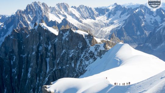
- You stand on the highest peak on Earth and feel a sense of victory few people know.
- Sherpa guides with wide experience lead each section of the climb and support your progress.
- Trekkers see Sherpa lifestyle, enjoy local food, and feel warm welcome in each village.
- The trail to Base Camp shows hills, forests, rivers, and villages filled with natural beauty.
- Climbers receive steady support from Base Camp to the high camps for safe movement.
- Himalayan views follow you from the first walk to the final push toward the summit.
Everest Expedition Overview
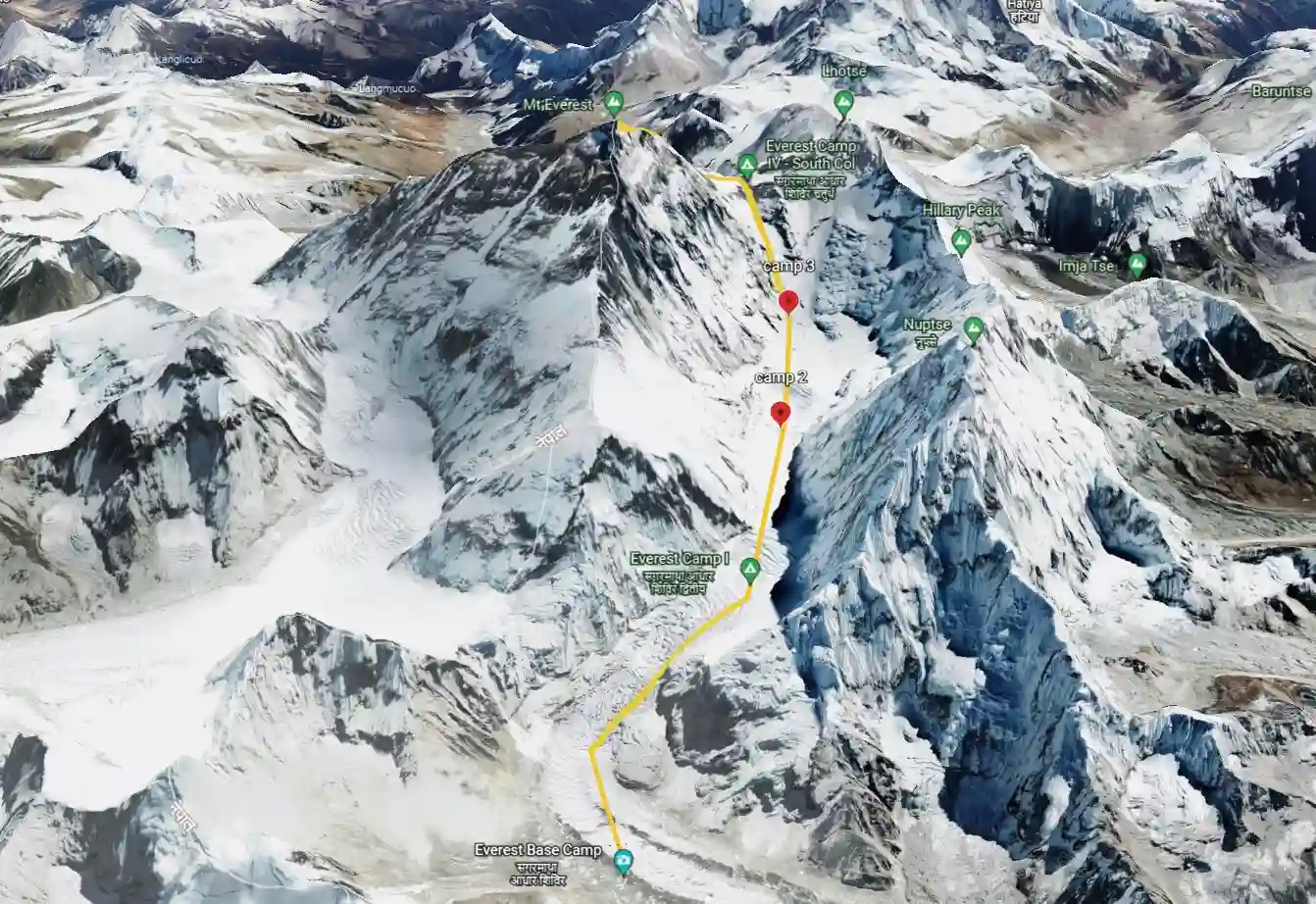
Mount Everest, Chomolungma in Tibetan, Sagarmatha in Nepali, stands at 8,848.86 metres (29,031.7 ft) above sea level on the border between Nepal and the Tibet Autonomous Region of China, making it the highest point on Earth. First summited on May 29, 1953 by Edmund Hillary of New Zealand and Tenzing Norgay Sherpa of Nepal as part of a British expedition led by John Hunt, Everest has since been climbed by over 7,269 individual climbers via a total of 13,737 documented ascents as of December 2025. Marvel Treks & Expedition operates guided Everest expeditions via the South Col Route — the standard Nepal-side route pioneered by Hillary and Tenzing, with veteran Sherpa guides, full oxygen systems, a structured 34-day itinerary, and complete permit management from the Nepal Department of Tourism briefing in Kathmandu to your summit certificate.
Key Facts Table
| Fact | Detail |
| Mountain | Mount Everest (Chomolungma / Sagarmatha / Peak XV / Qomolangma) |
| Elevation | 8,848.86 m / 29,031.7 ft (China-Nepal joint survey, December 2020) |
| World Rank | Highest mountain on Earth |
| Location | Solukhumbu District, Koshi Province, Nepal / Tibet Autonomous Region, China |
| Range | Mahalangur Himal, Himalaya |
| Standard Route | South Col Route (Southeast Ridge) — Nepal side |
| Alternative Route | Northeast Ridge (North Col Route) — Tibet side |
| Base Camp Altitude | 5,364 m / 17,598 ft (Nepal) / 5,150 m (Tibet — Rongbuk BC) |
| High Camps (South Col) | Camp I (6,065 m) → Camp II (6,400 m) → Camp III (7,200 m) → Camp IV South Col (7,925 m) |
| South Summit | 8,749 m — named subsidiary summit below the true summit |
| Expedition Duration | 34 days (Marvel Treks package) / 55-65 days full expedition |
| Best Season | Spring (March–May) — pre-monsoon, most stable summit windows |
| Secondary Season | Autumn (September–November) — fewer climbers, less stable weather |
| Protected Area | Sagarmatha National Park (Nepal) / Qomolangma NNR (Tibet) |
| Permit Cost (2026) | USD 15,000 per person — spring season, Nepal side (raised Sept 2025) |
| Permit Validity | 55 days (reduced from 75 days effective 2025) |
| Compulsory Guide Rule | 1 licensed guide per 2 climbers — mandatory for all 8,000 m peaks from Jan 2025 |
| First Ascent | Edmund Hillary (NZ) & Tenzing Norgay (Nepal), May 29, 1953 |
| First Winter Ascent | Leszek Cichy & Krzysztof Wielicki (Poland), February 17, 1980 |
| First Without Oxygen | Reinhold Messner (Italy) & Peter Habeler (Austria), May 8, 1978 |
| First Woman | Junko Tabei (Japan), May 16, 1975 |
| Speed Record | Nirmal Purja (UK/Nepal) — Everest as part of all 14 eight-thousanders in 189 days, 2019 |
| Most Summits | Kami Rita Sherpa — 31 ascents (record as of May 2025) |
| Total Summits (2025) | 13,737 total ascents / 7,269 unique climbers |
| Total Fatalities (2025) | 339 deaths since 1922 |
| Nepal-side fatality rate | 2.3% (229 deaths / 9,887 summits — Himalayan Database 2025) |
| Price from | USD $19,800 service package (see full cost breakdown below) |
| Day | Itinerary | Altitude | Duration |
|---|---|---|---|
| 1 | Arrival in Kathmandu | 1,400 m | — |
| 2 | Briefing & preparations in Kathmandu | 1,400 m | Full day |
| 3 | Fly to Lukla & trek to Phakding | 2,610 m → 2,610 m | 3–4 hrs |
| 4 | Trek from Phakding to Namche Bazaar | 3,440 m | 6–7 hrs |
| 5 | Acclimatization day at Namche Bazaar | 3,440 m | 3–4 hrs (hike) |
| 6 | Trek from Namche Bazaar to Pangboche | 3,985 m | 6–7 hrs |
| 7 | Trek from Pangboche to Dughla | 4,620 m | 5–6 hrs |
| 8 | Trek from Dughla to Gorakshep | 5,160 m | 4–5 hrs |
| 9 | Trek to Everest Base Camp | 5,364 m | 5–6 hrs |
| 10 | Puja ceremony & base camp preparation | 5,364 m | Full day |
| 11 | Icefall & technical training | 5,364 m | Full day |
| 12 | First rotation to Camp I | 6,065 m | 6–8 hrs |
| 13 | Rest day at Base Camp | 5,364 m | Full day |
| 14 | Move to Camp I | 6,065 m | 6–8 hrs |
| 15 | Move from Camp I to Camp II | 6,400 m | 6–8 hrs |
| 16 | Acclimatization day at Camp II | 6,400 m | Full day |
| 17 | Climb to Camp III & descend | 7,200 m | 6–8 hrs |
| 18 | Descend to Base Camp | 5,364 m | 6–8 hrs |
| 19 | Weather monitoring & summit preparation | 5,364 m | Full day |
| 20 | Begin summit push to Camp II | 6,400 m | 6–8 hrs |
| 21 | Move from Camp II to Camp III | 7,200 m | 6–8 hrs |
| 22 | Move to Camp IV (South Col) | 7,950 m | 6–8 hrs |
| 23 | Summit Day (Everest) | 8,848.86 m | 10–14 hrs |
| 24 | Descend to Base CampDescend to Base Camp | 5,364 m | 8–10 hrs |
| 25 | Contingency / extra summit day | Variable | - |
| 26 | Contingency / extra summit day | Variable | - |
| 27 | Equipment packing & load management | 5,364 m | Full day |
| 28 | Base Camp clean-up | 5,364 m | Full day |
| 29 | Expedition closing ceremony | 5,364 m | Half day |
| 30 | Trek from Base Camp to Pangboche | 3,985 m | 6–7 hrs |
| 31 | Trek from Pangboche to Namche Bazaar | 3,440 m | 6–7 hrs |
| 32 | Trek from Namche Bazaar to Lukla | 2,860 m | 6–7 hrs |
| 33 | Fly from Lukla to Kathmandu | 1,400 m | 35–40 min |
| 34 | Final departure | - | - |
- Arrival and Ground Services: International and domestic airport pick-up and drop-off are provided with a warm welcome by a Marvel Treks and Expeditions representative. All ground transportation in Kathmandu and guided sightseeing as per itinerary are included, excluding entrance fees.
- Accommodation: Kathmandu accommodation is arranged in a 3-star hotel on a twin-sharing Bed and Breakfast basis, with single rooms available at additional cost. Trekking lodges and fully serviced Base Camp and high-camp tents are provided during the expedition.
- Meals and Nutrition: Welcome and farewell dinners are included in Kathmandu, while lunch and dinner are excluded unless specified. During trekking and climbing, three hygienic meals daily with high-altitude nutrition and fresh vegetables are provided.
- Transportation and Logistics: All required domestic flights, jeep transport, and shared helicopter services as per the expedition itinerary are included. Cargo transport, porter support, and baggage movement to and from Base Camp are fully managed.
- Permits and Government Requirements: All Nepal Government climbing permits, national park permits, liaison officer arrangements, route fixing fees, garbage management charges, and applicable taxes are included. Company service and administrative charges are fully covered.
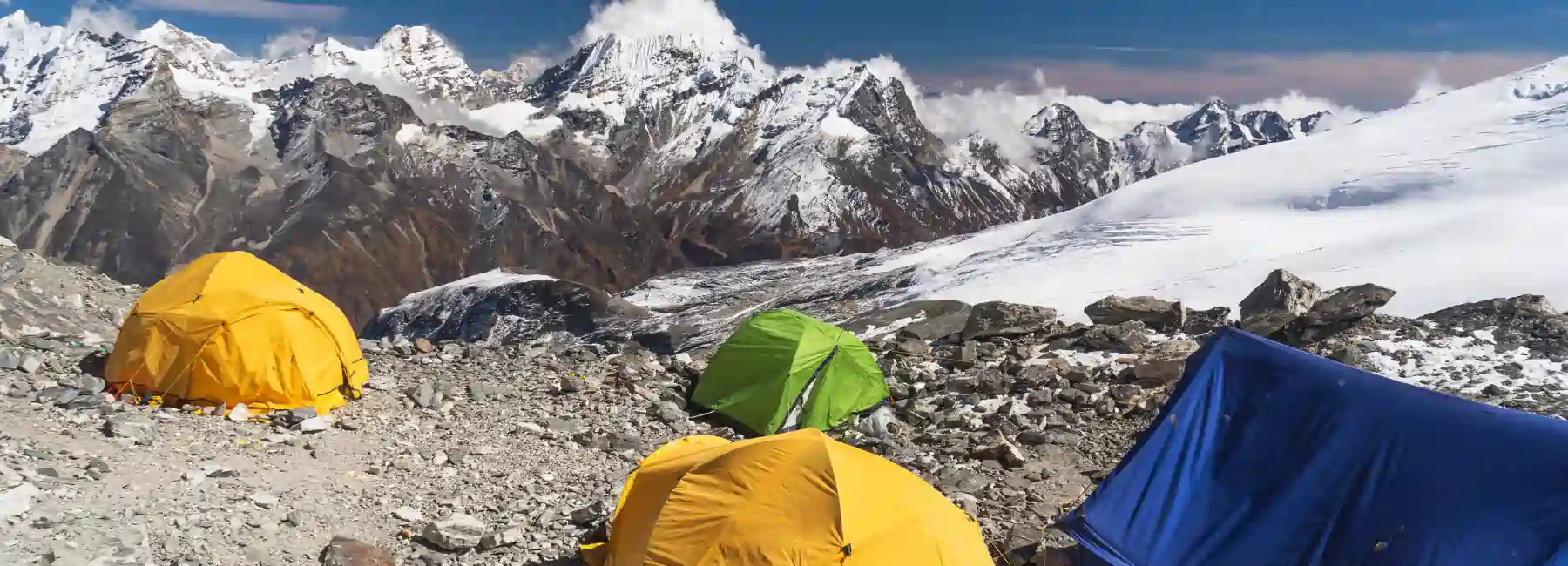
- Base Camp and High Camp Infrastructure: Base Camp is fully equipped with personal tents, dining and kitchen tents, power supply, toilets, and communication facilities. High camps are supported with quality expedition tents, climbing hardware, ropes, and cooking systems.
- Expedition Staff and Support: The expedition is led by an experienced leader with one government-licensed climbing Sherpa per member, supported by guides, cooks, porters, and Base Camp staff. All staff salaries, food, equipment, and insurance are included.
- Training, Oxygen, and High-Altitude Support: Pre-climb technical training and Sherpa assistance are provided at Base Camp. Each member receives four oxygen cylinders, with oxygen support for Sherpas and backup oxygen available if required.
- Communication, Safety, and Medical: Walkie-talkies, emergency satellite phone access, daily professional weather forecasts, and comprehensive first-aid support are provided. Medical support is available at Base Camp where conditions allow.
- Complimentary Items: Marvel Treks provides expedition duffle bags, branded apparel, route maps, and free use of basic equipment such as sleeping bags and down jackets. These items are provided for the duration of the expedition.
- Certification: Successful climbers receive an official summit certificate issued by the Government of Nepal along with expedition completion documentation from Marvel Treks and Expeditions.
- International Travel and Visa: International airfare to and from Nepal and Nepal entry visa fees are not included. Excess baggage and cargo charges on international and domestic flights are excluded.
- Meals and Beverages: Lunch and dinner in Kathmandu are excluded unless clearly stated in the itinerary. Personal snacks, bottled water, soft drinks, alcohol, cigarettes, and bar bills are not included.
- Personal Equipment: Personal climbing and trekking gear, clothing, bags, and packing items are not included. Personal medical kits, toiletries, and hygiene supplies must be arranged individually.
- Insurance and Medical: Personal travel insurance covering high-altitude rescue, helicopter evacuation, and emergency medical treatment is mandatory and not included. Medical examinations, clearance forms, and hospitalization costs are excluded.
- Extra Accommodation: Additional hotel nights in Kathmandu due to early arrival, late departure, flight delays, or personal itinerary changes are not included. Accommodation and meals outside official expedition dates are excluded.
- Communication and Internet: Internet usage, satellite phone calls, walkie-talkie charges, and Wi-Fi services outside Base Camp are not included. Personal communication expenses must be paid separately.
- Summit Bonus and Tips: Mandatory summit bonuses must be paid in cash after a successful ascent, including USD 2,000 per climbing Sherpa and USD 500 per kitchen staff. Tips for guides, porters, and Base Camp staff are recommended and excluded.
- Oxygen and Sherpa Support: Additional oxygen beyond the included cylinders and extra climbing Sherpas are not included. Extra masks, regulators, or oxygen systems are charged separately.
- Permits and Special Requests: Drone usage, filming, photography, and special media permits are excluded and subject to government approval. Customs duties for personal expedition equipment are not included.
- Personal and Miscellaneous Expenses: Laundry, hot showers, battery charging, personal purchases, refundable garbage deposits, and banking or transaction fees are excluded. Any personal expenses of any nature are the participant’s responsibility.
- Unforeseen Circumstances: Costs arising from natural disasters, extreme weather, political unrest, strikes, or changes in government regulations are excluded. Any service not specifically mentioned under cost includes is not covered.
Detailed Itinerary
Day 1: Arrival in Kathmandu
Upon arrival at Kathmandu airport, our representative will welcome you and transfer you to your hotel. You can relax after your journey or explore the city a little and enjoy traditional Nepali cuisine for dinner. Take the evening to stroll around Thamel and soak in the vibrant atmosphere of Kathmandu.
Day 2: Briefing and Preparations in Kathmandu
Your second day in Nepal is spent in Kathmandu preparing for the adventure ahead. There will be a detailed briefing with your guide to explain the itinerary, safety measures, and expedition tips, allowing you to clarify any questions and get to know your guide. You can also finalize any last-minute shopping or equipment arrangements in the city.
Day 3: Fly to Lukla and Trek to Phakding
After an early morning flight to Lukla, you will begin the trek to Phakding. The trail along the Dudh Koshi River offers beautiful scenery and helps your body gradually adjust to higher altitudes. Enjoy the first taste of the Khumbu landscape with mountains, rivers, and small Sherpa villages along the way.
Day 4: Trek from Phakding to Namche Bazaar
Trek through pine forests and cross several suspension bridges as you ascend toward Namche Bazaar. This bustling Sherpa town provides a perfect first stop for acclimatization with stunning views of the Himalayas. Take some time to explore the local market and enjoy the friendly atmosphere of the village.
Day 5: Acclimatization Day at Namche Bazaar
Spend the day acclimatizing at Namche Bazaar with short hikes to nearby viewpoints. You will have time to explore the local culture, enjoy Himalayan views, and prepare your body for the higher altitudes ahead. Visit the local monastery or the Everest View Hotel for panoramic vistas of the mountains.
Day 6: Trek from Namche Bazaar to Pangboche
Continue trekking through rhododendron forests and traditional Sherpa villages toward Pangboche. Along the way, enjoy close-up views of Everest, Ama Dablam, and other surrounding peaks. Take in the serene surroundings and observe the daily life of the Sherpa people.
Day 7: Trek from Pangboche to Dughla
Your trek ascends further into alpine terrain, passing monasteries and scenic ridges. Dughla provides a crucial stop before entering the upper Everest region. Enjoy the dramatic mountain scenery and the peaceful environment as you rest for the next day.
Day 8: Trek from Dughla to Gorakshep
Trek across glacial moraine to reach Gorakshep, preparing your body for the high-altitude conditions of Base Camp. You will witness spectacular views of the Khumbu Glacier and surrounding peaks along the way. Take some time to acclimatize and explore the surrounding hills for stunning photo opportunities.
Day 9: Trek to Everest Base Camp
From Gorakshep, you will trek to the iconic Everest Base Camp at 5,364 meters. This is a major milestone where you will see the Khumbu Icefall and set up your camp amidst the breathtaking Himalayas. Celebrate reaching Base Camp and take in the incredible sense of achievement.
Day 10: Puja Ceremony and Base Camp Preparation
Take part in a traditional puja ceremony for safety and success on Everest. The rest of the day will be spent preparing gear, organizing your camp, and reviewing the expedition plan. Meet other climbers at Base Camp and build camaraderie with your team.
Day 11: Icefall and Technical Training
Practice essential climbing techniques such as ladder crossings, rope handling, and icefall movement. This training ensures you are confident and safe for the challenging sections ahead. Your guide will provide tips and demonstrations to improve your skills.
Day 12: First Rotation to Camp I
Climb to Camp I at 6,050 meters to gain high-altitude experience, then return to Base Camp. This rotation is designed to help your body adapt to higher elevations gradually. Observe the Icefall closely to prepare for your future summit push.
Day 13: Rest Day at Base Camp
Enjoy a full rest day at Base Camp to recover and prepare for the next rotation. You can use this time to relax, review the route, and monitor your health and acclimatization. Take photos of the surrounding peaks or explore nearby glacier paths lightly.
Day 14: Move to Camp I
Re-ascend through the Icefall to Camp I for an overnight stay. Spending the night at this altitude helps improve your acclimatization and prepares you for higher camps. Enjoy the spectacular mountain sunrise or sunset from this vantage point.
Day 15: Move from Camp I to Camp II
Climb through the Western Cwm to reach Camp II at 6,500 meters. The valley offers challenging terrain and panoramic views that make the ascent rewarding. Take short breaks to admire the surrounding glaciers and peaks.
Day 16: Acclimatization Day at Camp II
Take a rest day at Camp II to allow your body to adapt to the higher altitude. Light movement, hydration, and rest are key to preparing for the next climb. Use this time to bond with fellow climbers and share experiences.
Day 17: Climb to Camp III and Descend
Ascend to Camp III at 7,100 meters on the Lhotse Face and then descend back to Camp II. This rotation is crucial for high-altitude acclimatization and summit readiness. Notice the changing snow and ice conditions as you climb higher.
Day 18: Descend to Base Camp
Return from Camp II to Base Camp for recovery. The descent allows your body to rest while maintaining acclimatization before the final summit push. Enjoy the serenity of Base Camp and the surrounding Himalayan panorama.
Day 19: Weather Monitoring and Summit Preparation
Spend the day monitoring weather conditions and finalizing your summit strategy. Gear checks, oxygen preparations, and mental readiness are emphasized. Meet with your Sherpa and expedition team to review key summit logistics.
Day 20: Begin Summit Push to Camp II
Climb from Base Camp to Camp II, pacing yourself carefully to conserve energy. This is the start of the critical rotation leading to the summit attempt. Take in the breathtaking views along the Western Cwm as motivation.
Day 21: Move from Camp II to Camp III
Ascend to Camp III using fixed ropes and supplemental oxygen. Overnight at this altitude prepares you for the final push to the summit. Observe the Lhotse Face and practice techniques learned during training.
Day 22: Move to Camp IV at South Col
Climb to Camp IV at 7,900 meters on the South Col. Rest and prepare your oxygen systems and equipment for the summit day ahead. Take some time to acclimatize and enjoy the high-altitude environment safely.
Day 23: Summit Day
Begin the final ascent from Camp IV to the summit of Everest at 8,848.86 meters. After celebrating your achievement at the top, carefully descend back to Camp IV for rest. Capture the once-in-a-lifetime views and the feeling of standing above the world.
Day 24: Descend to Base Camp
Descend safely through the higher camps back to Base Camp. Take time to reflect on your summit achievement and enjoy the mountain scenery. Share your experiences and celebrate with your expedition team.
Day 25–26: Contingency or Extra Summit Days
These days are reserved for weather delays, extra summit attempts, or rest. They provide flexibility and safety for your expedition schedule. Use this time to rest, recover, or explore the surrounding areas.
Day 27: Equipment Packing and Load Management
Pack and organize your expedition gear for the return trek. Carefully manage loads to ensure safe transport from Base Camp. Double-check equipment and secure any items for the descent.
Day 28: Base Camp Cleanup
Participate in Base Camp cleanup following Leave No Trace principles. Proper disposal of all waste ensures environmental responsibility. Reflect on your journey and take final photos of the iconic Everest landscape.
Day 29: Expedition Closing Ceremony
Attend the closing ceremony at Base Camp and receive your certificates. Celebrate your achievements with the team and share memories of the journey. Take the opportunity to thank your Sherpas and support staff.
Day 30: Trek from Base Camp to Pangboche
Begin the return trek from Base Camp to Pangboche. Enjoy the beautiful trail and scenic views as you descend into lower elevations. Observe local villages and mountain scenery along the way.
Day 31: Trek from Pangboche to Namche Bazaar
Continue trekking through Sherpa villages and alpine forests. Overnight stay in Namche Bazaar allows for rest and acclimatization before continuing the descent. Explore the village market or relax at a teahouse in the evening.
Day 32: Trek from Namche Bazaar to Lukla
Complete the trek back to Lukla, marking the end of the trekking portion. Celebrate the journey and the memories made along the trail. Take in the last views of the Himalayas before flying out.
Day 33: Fly from Lukla to Kathmandu
Take a scenic flight back to Kathmandu from Lukla. Transfer to your hotel and rest after the challenging trek. Enjoy the city ambiance and a celebratory dinner with the expedition team.
Day 34: Final Departure
Transfer to Kathmandu airport for your onward journey. Conclude the Everest expedition with memories, certificates, and a sense of accomplishment. Reflect on your extraordinary journey and the adventure you have completed.
Trip Map
What Is Mount Everest? Chomolungma, Sagarmatha, and the Roof of the World
Mount Everest is known by four names that reflect the cultures surrounding it. Sagarmatha — meaning goddess of the sky or forehead of the sky, is the Nepali name and the designation used by Sagarmatha National Park, the UNESCO World Heritage Site protecting the Khumbu Valley on the mountain’s southern flank. Chomolungma, meaning goddess mother of the world in Tibetan, is the name used by the Sherpa community and the Tibetan side. If you’re wondering where is Mount Everest, it sits on the border between Nepal and Tibet (China). Peak XV was the original survey designation assigned by Andrew Waugh of the Great Trigonometrical Survey of India in 1856, who named the mountain after his predecessor George Everest. Qomolangma is the Chinese Mandarin transliteration of Chomolungma, used in all Chinese official references and on the Tibet side.
Everest sits precisely on the Nepal-China border at coordinates 27.9881° N, 86.9250° E, in the Mahalangur Himal sub-range of the Himalaya. Its nearest major neighbours are Lhotse (8,516 m, 4th highest in the world, immediately to the south and sharing the South Col with Everest), Nuptse (7,861 m, the dramatic west buttress visible from Everest Base Camp), Changtse (7,543 m, the north peak visible from the Tibetan side), and Pumori (7,161 m, the pyramid visible from Base Camp). From the summit of Everest on a clear day, the curvature of the Earth is visible to the naked eye. The view encompasses Makalu, Kangchenjunga, Lhotse, Cho Oyu, and hundreds of named peaks across Nepal, Tibet, Bhutan, and northern India.
The elevation of 8,848.86 m was confirmed by a China-Nepal joint survey completed in December 2020. This figure supersedes the previous official height of 8,848 m established by the Survey of India in 1954, and the 8,850 m figure used by National Geographic from 1999. The 2020 measurement used satellite positioning, gravimetric data, and gravity reference adjustments to arrive at the most precise elevation ever recorded for the mountain. The extra 0.86 m includes the surveyed snow/ice cap on the summit — the bedrock height was measured as 8,844.43 m.
Everest Summit Statistics, Success Rates, and Fatality Data
Mount Everest has been summited more than any other 8,000-metre peak in history. As of December 2025, the Himalayan Database records 13,737 total ascents by approximately 7,269 individual climbers. Repeat ascents — primarily by Sherpa guides, account for a significant share of the total: Kami Rita Sherpa alone holds the record with 31 summits as of May 2025.
| Statistic | Data (Himalayan Database, December 2025) |
| Total summits (all time) | 13,737 ascents |
| Total individual climbers | 7,269 unique people |
| Total fatalities (since 1922) | 339 deaths |
| Nepal (South) side summits | 9,887 |
| Nepal (South) side fatality rate | 2.3% (229 deaths) |
| Tibet (North) side summits | 3,850 |
| Tibet (North) side fatality rate | 2.8% (110 deaths) |
| Combined overall fatality rate | 1.07 deaths per 100 summits (normalized) |
| Overall success rate (all expeditions 1990-2025) | 29% |
| Commercial guided South Col success rate | 55-70% in stable-weather seasons |
| 2025 Nepal-side client success rate | 49% |
| Deaths per year (modern avg) | 4-8 deaths per season |
| Primary cause of death | Falls (35%), avalanche (22%), altitude illness (15%), exposure (8%) |
| Deaths on descent vs ascent | Majority on descent — fatigue, oxygen depletion, darkness |
| Deadliest single event | 2014 Khumbu Icefall avalanche — 16 Sherpa deaths |
| Deadliest season | 1996 — 15 deaths including Rob Hall and Scott Fischer |
| 2025 season deaths | 2-5 reported fatalities |
| No-oxygen ascents (% of total) | ~1.4% of all summits — dramatically higher fatality rate |
| Low-cost expedition correlation | 23 of 26 deaths in 2023-2024 combined occurred on below-median-cost expeditions |
The correlation between expedition budget and safety is one of the most significant findings of modern Everest analysis. According to Alan Arnette’s 2026 statistical review, 23 of the 26 Everest fatalities across 2023 and 2024 combined occurred on expeditions operating at or below the median price point. This data reinforces what experienced operators have argued for decades: that adequate Sherpa ratios, sufficient oxygen supplies, and robust logistical support are not luxuries on Everest, they are the operational foundation of survival. Nepal’s response — the mandatory guide-to-climber ratio rule (January 2025) and the $15,000 permit fee increase (September 2025) — is explicitly designed to price out the most underfunded and therefore most dangerous expedition models.
Mount Everest Climbing Routes — South Col vs North Ridge
Everest has been climbed by over 18 distinct routes since 1953, but two dominate commercial expeditions: the South Col Route from Nepal (Southeast Ridge) and the Northeast Ridge (North Col Route) from Tibet. The choice of Everest climbing route depends on factors such as permit regulations, logistics, acclimatization strategy, and climber experience. Approximately 72% of all Everest summits use the South Col route.
South Col Route (Southeast Ridge) — Standard Nepal Route
The South Col Route was first climbed by Edmund Hillary and Tenzing Norgay on May 29, 1953. It ascends Everest’s southeast aspect from Base Camp at 5,364 m through the Khumbu Icefall and Western Cwm to the South Col (7,925 m), then up the Southeast Ridge to the summit. The route features the following named technical features — all of which are top-searched Everest sub-queries:
- Khumbu Icefall (5,400–6,000 m): The most objectively dangerous section of the route, immediately above Base Camp. A moving, chaotic mass of broken glacier containing massive seracs (ice towers), deep crevasses, and shifting ice bridges crossed via aluminium ladders. The route through the Icefall is fixed each season by the Icefall Doctors — specialist Sherpas employed by the Sagarmatha Pollution Control Committee (SPCC). The Icefall is crossed before dawn to minimize serac fall risk during warmer daytime temperatures. The 2014 Khumbu Icefall avalanche, triggered by a serac collapse, killed 16 Sherpas and remains the single deadliest incident in Everest history.
- Western Cwm (6,000–6,400 m): A broad, flat glacial basin also called the Valley of Silence, running southwest to northeast between Everest’s Southwest Face, the Lhotse Face, and the west ridge of Nuptse. At 6,000 m altitude with walls blocking wind, the Cwm can become extraordinarily warm during the day — temperatures above 35°C are documented inside the reflective snow bowl. Camps I (6,065 m) and II (6,400 m) are located within the Cwm.
- Lhotse Face (6,400–7,200 m): A massive, near-continuous 40–50 degree ice wall rising from Camp II at 6,400 m to Camp III at 7,200 m. One of the longest sustained ice faces on the South Col route, requiring fixed rope ascent for approximately 800 vertical metres. The Lhotse Face is where climbers first experience the physiological effects of extreme altitude — Camp III at 7,200 m is well within the severe altitude zone.
- Yellow Band (7,000–7,200 m): A distinctive layer of yellowish limestone running across the upper Lhotse Face. The Yellow Band requires crampon care as limestone rock is exposed beneath thin ice, creating a mixed terrain section on an otherwise pure-snow route. Named for its colour visible from Base Camp and Kala Patthar.
- Geneva Spur (7,200–7,900 m): A rocky promontory above Camp III connecting the Lhotse Face to the South Col. Named by a 1952 Swiss expedition. The Spur requires scrambling over mixed terrain and typically features fixed ropes. Above the Geneva Spur, the angle eases and the South Col comes into view.
- South Col / Camp IV (7,925 m): A windswept saddle between Everest and Lhotse at 7,925 m — one of the highest campsites on Earth. Abandoned oxygen bottles, tent remains, and equipment debris from decades of expeditions litter the Col. Camp IV is the launch point for summit day and sits approximately 75 metres below the death zone threshold of 8,000 m. In good conditions, teams leave Camp IV between midnight and 2:00 AM for the 8–12 hour summit push.
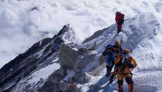
- The Balcony (8,400 m): A broad snow terrace at approximately 8,400 m where the Southeast Ridge briefly flattens. The Balcony is the primary rest and oxygen-check point on summit day, providing an unobstructed view of the upper mountain and the first clear sighting of the South Summit. Turnaround decisions are often made here if conditions deteriorate.
- South Summit (8,749 m): A false summit, a prominent snow dome at 8,749 m — lies below the true summit and is often misidentified as the top by climbers below. From the South Summit, climbers descend a short distance before traversing the corniced Southeast Ridge toward the former Hillary Step. The South Summit is the highest point on the route before the true summit ridge.
- The Hillary Step / Former Hillary Step (8,790 m): A near-vertical 12-metre rock band at approximately 8,790 m was the defining technical crux of the South Col Route for decades. Named for Edmund Hillary, who first climbed it in 1953. Post-2015 earthquake surveys and climber reports from 2017 onward indicate the Hillary Step as a distinct rock band has substantially changed — many climbers report the section now resembles a steep snow and ice ridge rather than a rock step. Marvel Treks guides brief all summit teams on current conditions at this section each season, as the terrain evolves.
- Summit Ridge (8,790–8,848.86 m): The final exposed ridge from the former Hillary Step to the true summit. The ridge is heavily corniced on the right (Tibetan side) — an invisible overhang of compacted snow projecting beyond the visible edge. Climbers must stay on the left (Nepalese side) of the apparent ridge crest. The true summit is a small, exposed snow platform approximately 4 m × 4 m — large enough for 4–5 people standing together.
Northeast Ridge (North Col Route) — Tibet Side
The Northeast Ridge ascends Everest’s northern aspect from Rongbuk Monastery in Tibet via the East Rongbuk Glacier and North Col (7,028 m). The route passes through the three technical steps above 8,500 m, the First Step, Second Step, and Third Step — before reaching the summit. The Second Step, at approximately 8,610 m, includes a Chinese-installed ladder (1975) that remains in place, making this the crux of the northern route. Approximately 28% of Everest summits use the Northeast Ridge.
Key differences from the South Col route: no Khumbu Icefall hazard, but longer approach from Lhasa, China Tibet Mountaineering Association (CTMA) permit required ($15,800–$18,000), restricted helicopter rescue access (Tibet does not allow civilian helicopter rescue as routinely as Nepal), and generally colder and windier conditions at similar elevations. Tibet already formally requires a documented 7,000-metre prior ascent to receive an Everest permit — a requirement Nepal is actively discussing adopting.
2026 Permit Costs and New Regulations
The $15,000 Permit — What Changed in 2026
The Nepal government increased the Mount Everest climbing permit fee from USD 11,000 to USD 15,000 per person effective September 1, 2025 — a 36% increase. If you’re wondering, Do I need permit to climb Everest, the answer is yes; every climber must obtain a valid climbing permit through a licensed expedition operator. This applies to all 2026 expeditions regardless of when the deposit was placed (climbers who had confirmed 2025 spring bookings before the cutoff were grandfathered at USD 11,000, but this exemption does not extend to 2026). The stated rationale from Nepal’s Ministry of Culture, Tourism and Civil Aviation is threefold: garbage management and mountain cleanup, social security funding for high-altitude Sherpa workers, and general revenue for rescue infrastructure.
Additional key changes effective from September 2025 and January 2025 respectively:
- Permit validity reduced from 75 days to 55 days — all expedition logistics must complete within this window
- Compulsory guide requirement — 1 licensed Nepali guide for every 2 climbers on any peak above 8,000 m (effective January 2025)
- Mandatory death repatriation insurance — minimum NPR 5 million (~USD 37,500) per climber
- Increased insurance for high-altitude guides — minimum NPR 2 million (~USD 15,000) per Sherpa guide
- Mandatory biodegradable waste bags — all climbers must carry poop bags and return human waste to Base Camp
- Paragliding permitted only during descent with prior approval on peaks above 8,000 m
The New Summit+ Premium Permit (2026)
Nepal’s Ministry announced the FastClimb Premium Summit+ permit in early March 2026 — a limited-availability surcharge permit priced at USD 12,000 on top of the standard USD 15,000 permit (total: USD 27,000 for permit alone). Summit+ holders receive priority right-of-way on all fixed lines during both ascent and descent — other climbers are required to unclip from fixed ropes and move to designated waiting snowbanks to allow Summit+ climbers to pass. A limited number of Summit+ permits were available for the 2026 spring season on a trial basis.
Marvel Treks’ position on Summit+: Our small-team expedition model (maximum 6–8 clients) and strategic departure timing from Camp IV are specifically designed to minimize wait time in the death zone without a priority permit surcharge. Contact us to discuss how our departure scheduling compares to a Summit+ permit for your specific expedition goal.
Complete 2026 Permit Fee Structure
| Permit / Fee | Cost (USD) | Notes |
| Climbing Royalty Permit (spring) | $15,000 per person | Nepal Dept of Tourism — 36% increase from $11,000 (effective Sept 2025) |
| Climbing Royalty Permit (autumn) | $7,500 per person | Secondary season — fewer teams, less stable weather |
| Summit+ Premium Permit (optional, 2026 trial) | $12,000 surcharge | Priority right-of-way on fixed lines — limited availability |
| Garbage deposit (refundable) | $4,000 per team | Refunded if team brings all waste to BC for proper disposal |
| Liaison Officer fees & allowances | $2,000-3,000/team | Government-appointed LO must accompany all teams |
| Sagarmatha National Park entry fee | $30 per person | Mandatory for Khumbu Valley approach |
| SPCC Icefall Doctors / route-fixing fee | Included in team fee | Sagarmatha Pollution Control Committee charges per-team for Icefall route |
| TIMS card | $20 per person | Trekkers Information Management System — approach trek |
| Death repatriation insurance minimum | NPR 5M ($37,500) | New mandatory requirement effective Sept 2025 |
Full Expedition Cost Breakdown — $19,800 vs Total Budget
Marvel Treks’ USD 19,800 service package covers the logistics, Sherpa staff, equipment, and support managed by our team. If you’re wondering how much does it cost to climb Everest, the total all-in expedition budget includes several additional mandatory expenses that every climber must pay beyond the expedition package. Here is a fully transparent breakdown:
| Cost Component | Estimated Amount (USD) |
| Marvel Treks Service Package | $19,800 — included in our quote |
| Nepal Climbing Royalty Permit (spring 2026) | $15,000 per person — mandatory |
| Garbage deposit (refundable) | $4,000 per team — Marvel Treks manages |
| Liaison Officer fees | $2,000–$3,000 per team |
| Sagarmatha National Park fee | $30 per person |
| SPCC route-fixing fee | Included in team logistics |
| TIMS card | $20 per person |
| International flights to/from Kathmandu | $800–$3,000 depending on origin |
| Domestic flight Kathmandu–Lukla (return) | ~$400–$600 per person |
| Nepal entry visa | $50–$125 depending on duration |
| Personal climbing gear (if purchasing) | $5,000–$15,000 first-time buyers |
| High-altitude expedition insurance (mandatory) | $2,000–$5,000 — must cover 8,848 m |
| Summit bonus — Climbing Sherpa (mandatory cash) | $2,000 per Sherpa (included in Cost Includes) |
| Summit bonus — Kitchen staff (mandatory cash) | $500 per staff member |
| Satellite communicator (personal) | $500–$1,000 |
| Personal snacks, supplements, and medications | $500–$1,500 |
| Tips for all staff (strongly recommended) | $500–$2,000 |
| Personal expenses and contingency buffer | $2,000–$5,000 |
| Summit+ Premium Permit (optional) | $12,000 additional if desired |
| ESTIMATED TOTAL ALL-IN BUDGET | $45,000 – $75,000 for Marvel Treks clients |
| Industry premium operator range | $80,000 – $130,000+ (Western-led luxury operators) |
Marvel Treks clients typically fall in the $45,000–$75,000 total range — below the industry average for full-service operators and significantly below luxury Western-led expeditions. This reflects our Nepal-based operational model, which eliminates Western guide markup costs without reducing safety standards. Our Sherpa team includes multiple Everest summit holders with verified experience. Contact Marvel Treks for a personalised cost breakdown based on your gear situation, nationality, and flight origin.
Mount Everest Climbing History — Key Expeditions and Milestones
1921–1952: The British Quest
The British began systematically attempting Everest via the Tibet (north) side in 1921, after Nepal was closed to foreigners. George Mallory and Andrew Irvine disappeared near the summit on June 8, 1924 — whether they summited before dying remains one of mountaineering’s greatest unresolved questions. Mallory’s body was found on the North Face in 1999 by Conrad Anker; Irvine’s body and camera (which could resolve the summit question) have never been recovered. Swiss climbers Raymond Lambert and Tenzing Norgay reached 8,595 m via the Southeast Ridge in 1952 — establishing the South Col route and coming within 253 metres of the summit before retreating. Lambert and Tenzing’s 1952 high point gave the British expedition of 1953 a proven route.
May 29, 1953: First Ascent — Hillary and Tenzing
The first successful ascent of Mount Everest was made at approximately 11:30 AM on May 29, 1953 by Edmund Hillary of New Zealand and Tenzing Norgay Sherpa of Nepal, as part of the ninth British Expedition led by Colonel John Hunt. They spent approximately 15 minutes on the summit, taking photographs, looking for evidence of Mallory and Irvine, and burying a small chocolate and prayer flags as offerings. Hillary photographed Tenzing on the summit; Tenzing, who had never used a camera, did not photograph Hillary. The news reached London on June 2, 1953 — the morning of Queen Elizabeth II’s coronation — making the ascent one of the defining news events of the post-war era. Both Hillary and Tenzing were awarded the George Cross and Order of the British Empire. Hillary was later knighted.
1960: First Ascent of the North Side (China)
On May 25, 1960, a Chinese expedition made the first ascent of Everest via the Northeast Ridge from Tibet. The summit team — Wang Fuzhou, Gonpo (Gongbu), and Qu Yinhua — reached the summit at night and claimed the first ascent of the Second Step, a near-vertical 5-metre rock wall at 8,610 m on the northern route. The 1975 Chinese expedition installed an aluminium ladder at the Second Step that remains in place today, used by essentially all climbers on the northeast route.
1975: First Woman — Junko Tabei
Junko Tabei of Japan became the first woman to summit Everest on May 16, 1975, via the South Col route. Tabei was leading an all-female Japanese expedition when an avalanche struck their camp at 6,300 m on May 4, burying several climbers. Tabei herself was rendered unconscious and had to be dug out by Sherpas. Despite injuries, she continued and summited 12 days later with Sherpa Ang Tsering. Tabei later became the first woman to complete the Seven Summits, in 1992. She died of cancer in October 2016.
1978: First Ascent Without Supplemental Oxygen
On May 8, 1978, Reinhold Messner of Italy and Peter Habeler of Austria reached the summit of Everest via the South Col Route without supplemental oxygen — an achievement widely believed impossible by the medical community at the time. Messner and Habeler’s ascent fundamentally changed the understanding of human physiological limits at extreme altitude. Messner returned in 1980 to solo Everest without oxygen via a new route on the North Face — the most audacious solo high-altitude climb in history. These ascents remained central to the debate about whether Everest could be climbed without oxygen aid.
1980: First Winter Ascent — Polish Alpinism’s Golden Age
On February 17, 1980, Leszek Cichy and Krzysztof Wielicki of Poland made the first winter ascent of Everest via the South Col Route. They summited at 14:40 in temperatures below -40°C with hurricane-force winds — conditions so extreme that their tent poles bent under wind load at Camp IV. The Polish winter ascent was part of an extraordinary era in which Polish alpinists dominated winter eight-thousander climbing, completing first winter ascents of Makalu, Kangchenjunga, and Dhaulagiri in the same decade.
1992: Commercialisation Begins
The modern era of commercial Everest expeditions began in earnest in 1992 when Rob Hall and Gary Ball of Adventure Consultants guided four paying clients to the summit — the first large-scale commercial guided ascent. Rob Hall and Scott Fischer’s teams were among the pioneers of the guided Everest model that has since dominated the mountain. The 1985 ascent of Everest by Dick Bass with guide David Breashears is often cited as an earlier milestone in commercialisation, but the systematic operator model — fixed camps, hired Sherpas, paying clients — emerged through the early 1990s.
1996: The Deadliest Season — Into Thin Air
May 10–11, 1996 saw the deaths of 15 climbers in a single storm — the most fatalities in a single Everest season at the time. Among the dead were Rob Hall (New Zealand), the world’s most experienced commercial Everest guide who died at the South Summit after helping a client descend; Scott Fischer (USA), leader of Mountain Madness; and several other team members from multiple nationalities. Jon Krakauer’s account of the disaster, Into Thin Air, published in 1997, became one of the bestselling non-fiction books of the decade and permanently shaped public understanding of Everest. The 1996 disaster drew attention to: summit fever (continuing past turnaround times), crowding on the Southeast Ridge, commercial pressure to summit, and the weather forecasting limitations of the era.
2014: The Khumbu Icefall Disaster
On April 18, 2014, a massive serac collapse in the Khumbu Icefall at approximately 5,800 m struck a group of Sherpas carrying loads to higher camps before dawn. Sixteen Sherpa guides died — the single deadliest incident in Everest history. The dead included some of Nepal’s most experienced high-altitude guides. The disaster triggered a Sherpa walkout, widespread calls for improved compensation and insurance, and ultimately the cancellation of the entire 2014 spring season. The Nepal government subsequently increased Sherpa death compensation and mandatory insurance coverage.
2015: Nepal Earthquake and Base Camp Avalanche
On April 25, 2015, a 7.8-magnitude earthquake struck Nepal, triggering an avalanche from the slopes of Pumori that swept through Everest Base Camp. Twenty-two people died at Base Camp — the most deaths ever recorded at Base Camp in a single event. The 2015 season was cancelled. The earthquake and its aftershocks caused significant damage to trail infrastructure throughout the Khumbu Valley and triggered ongoing discussion about the positioning of Everest Base Camp relative to Pumori’s avalanche path.
2019: The Crowding Crisis and the Famous Queue Photo
In May 2019, photographer Nirmal Purja captured an image of over 200 climbers queuing on the Southeast Ridge near the Hillary Step — a photograph that went viral globally and sparked international debate about Everest crowding, permit limits, and the commercialisation of the world’s highest summit. Nepal issued 381 permits in 2019, resulting in 891 summits. Eleven climbers died that season. Post-season analysis found no direct evidence that queuing caused deaths through oxygen depletion alone — most fatalities involved late summit times, ignored turnaround protocols, or pre-existing altitude illness rather than crowding directly. Nevertheless, the image permanently shifted the public and regulatory conversation about summit management.
2019: Nirmal Purja’s Speed Record
In 2019, Nirmal Purja (UK/Nepal) completed the ascent of all 14 eight-thousanders in 189 days — shattering the previous record of 7 years, 10 months, 6 days set by South Korean climber Kim Chang-ho. Purja summited Everest on May 22, 2019, as part of Project Possible. His 14-summit journey was documented in the Netflix film 14 Peaks: Nothing Is Impossible (2021). Purja’s achievements — including his leadership of the 2021 first winter ascent of K2 — have made him the most publicly prominent Nepalese climber since Tenzing Norgay.
2020 to Present: New Elevation, Growing Numbers
In December 2020, China and Nepal jointly announced the revised official elevation of Mount Everest as 8,848.86 m — the most precise measurement ever made. The 2021 and 2022 seasons saw returning high permit numbers after the COVID-19 pandemic forced cancellation in 2020. By 2024, Nepal issued approximately 650 permits, resulting in 861 summits. Kami Rita Sherpa set a new record with his 31st summit in May 2025. The ongoing debate over permit limits, experience requirements, and the new premium Summit+ tier defines the regulatory environment entering the 2026 season.
Khumbu Icefall — The Most Dangerous Section of the South Col Route
The Khumbu Icefall deserves dedicated coverage because it is the most-searched specific hazard on Everest and the primary safety concern for buyers evaluating expedition operators. The Icefall is a section of the Khumbu Glacier that flows over a steep underlying bedrock step, causing the glacier to fracture into a chaotic jumble of ice towers, crevasses, and unstable ice blocks. The section extends from approximately 5,400 m (just above Base Camp at 5,364 m) to approximately 6,000 m, spanning a vertical gain of around 600 m.
- Icefall Doctors: A team of specialist Sherpas employed by the Sagarmatha Pollution Control Committee (SPCC) fixes the route through the Khumbu Icefall at the start of each season. They place aluminium ladders across crevasses, fix ropes on ice walls, and maintain the route throughout the season as the glacier moves. Icefall Doctors are among the most respected and highest-paid members of the Everest workforce.
- Movement pattern: The Khumbu Glacier moves approximately 1 metre per day in the Icefall zone. This constant movement shifts crevasse locations, destabilises ladder placements, and causes serac towers to lean and eventually collapse. The Icefall Doctors make daily route inspections and repairs throughout the season.
- Timing: Marvel Treks schedules all Khumbu Icefall crossings to begin no later than 4:00 AM and to complete the crossing before 9:00 AM. Solar warming after sunrise accelerates serac instability — the 2014 collapse occurred at approximately 6:45 AM, after sunrise. Early morning crossings are non-negotiable.
- Serac collapse: The primary hazard in the Icefall is ice tower (serac) collapse without warning. Seracs in the Khumbu Icefall can be the size of multi-story buildings. The 2014 event was caused by a serac above approximately 5,800 m releasing onto a group of Sherpas. No amount of route experience eliminates this objective hazard — only timing discipline minimises it.
- Alternative route discussions: After the 2014 disaster, multiple proposals for helicopter access to above the Icefall were explored. Nepal ultimately prohibited helicopter shortcuts to acclimatisation camps, maintaining the requirement to climb through the Icefall as part of the acclimatisation process. Some premium operators offer helicopter acclimatisation at Namche Bazaar (3,440 m) or Ama Dablam Base Camp (4,600 m) to reduce Icefall exposure time during early rotations.
The Death Zone on Everest — Physiology, Risk, and Survival
Everest death zone begins at 8,000 metres (26,247 ft). On the South Col route, climbers enter the death zone at Camp IV (South Col, 7,925 m is slightly below) and remain in it for the entire summit push — typically 8–16 hours on summit day. The Everest summit at 8,848.86 m sits 848 metres above the death zone threshold.
In the death zone, atmospheric pressure is approximately one-third of sea level. A breath at the summit of Everest delivers approximately the same oxygen as taking one-third of a breath at sea level. The human body cannot acclimatise to this altitude — it can only tolerate it briefly before deteriorating. Documented physiological effects above 8,000 m include:
- Impaired judgement and decision-making — the primary killer on Everest, responsible for the majority of turnaround rule violations and late-summit deaths
- Severe hypoxia — oxygen deprivation causing visual disturbances, hallucinations, and loss of motor coordination
- HACE (High Altitude Cerebral Edema) — fluid accumulation in the brain. Onset can be rapid above 8,000 m. Symptoms: severe headache, ataxia (inability to walk a straight line), confusion, drowsiness. Fatal within hours if untreated. Treatment: immediate descent and Dexamethasone. All Marvel Treks Sherpa guides carry Dexamethasone above Camp III.
- HAPE (High Altitude Pulmonary Edema) — fluid in the lungs. Symptoms: breathlessness at rest, persistent cough, pink frothy sputum, low SpO2 on pulse oximeter. Can develop rapidly during summit night and prevent descent. Treatment: immediate descent, supplemental oxygen, Nifedipine.
- Frostbite — at summit temperatures of -20°C to -35°C (spring), exposed skin can suffer frostbite within minutes. Extremities — fingers, toes, nose, ears — are primary frostbite sites. Marvel Treks provides comprehensive guidance on layering strategy to minimize frostbite risk.
- Oxygen depletion — each climber uses approximately one 4-litre bottle per 6–8 hours at a flow rate of 2 l/min. Running out of oxygen in the death zone is a medical emergency. Marvel Treks provides 4 bottles per climber above Camp IV with additional emergency backup.
Marvel Treks enforces a hard turnaround time of 2:00 PM on all summit days regardless of position on the mountain. Statistical analysis of Everest fatalities shows that the majority of summit-day deaths involve climbers who summited after 2:00 PM — either because they were too slow to safely descend before darkness and deteriorating conditions, or because exhaustion from a late push impaired their descent judgement. This rule is non-negotiable on all Marvel Treks expeditions.
Acclimatization Strategy for Everest — Rotations, Schedule, and Physiology
Everest requires more acclimatization time and more structured rotation cycles than any other commercially guided 8,000-metre peak. The altitude gain from Base Camp (5,364 m) to the summit (8,848.86 m) is 3,484 vertical metres — the largest altitude gain on any eight-thousander standard route. Marvel Treks builds two full acclimatization rotations into the expedition before the summit push, in addition to the initial EBC trek acclimatization.
Acclimatization Rotation Schedule
| Phase | Climb To | Sleep At | Purpose |
| EBC Trek | Base Camp (5,364 m) | Various camps | Gradual altitude introduction via 8-day trek from Lukla |
| Rotation 1 | Camp I (6,065 m) | Base Camp (5,364 m) | First Icefall crossing, initial altitude stimulus |
| Rotation 1b | Camp II (6,400 m) | Camp I (6,065 m) | Extend acclimatization into Western Cwm |
| Rotation 2 | Camp III (7,200 m) | Camp II (6,400 m) | Lhotse Face acclimatization, oxygen systems introduction |
| Rotation 2b | Camp IV (7,925 m) optional | Camp III (7,200 m) | Death zone exposure, summit-day rehearsal conditions |
| Rest at BC | Base Camp | Base Camp | Recovery, weather monitoring, summit window assessment |
| Summit push | Camp IV → 8,848.86 m | Camp III or lower | Summit attempt via Balcony, South Summit, summit ridge |
The decision of whether to include a Camp IV rotation before the summit push depends on weather windows, team condition, and season timing. In spring seasons with early stable windows, teams sometimes skip the Camp IV rotation to preserve physical condition. Marvel Treks expedition leaders make this call in consultation with the professional weather forecasting service during the pre-summit period.
Everest vs. Other 8,000-Metre Peaks — Comparison for Serious Climbers
| Factor | Everest (8,848 m) | K2 (8,611 m) | Manaslu (8,163 m) | Cho Oyu (8,188 m) |
| World rank | 1st | 2nd | 8th | 6th |
| Fatality rate | 2.3% (Nepal side) | 9.5% | 2.7% | 1.5% |
| Technical difficulty | Moderate-high | Extreme | High | Moderate |
| Summit success rate | 55-70% (guided) | 25% | 55-65% | 60-70% |
| Permit cost | $15,000 (spring 2026) | $5,000 (Pakistan) | $3,000 (autumn) | $1,500 (Tibet) |
| Best season | Spring (March-May) | Summer (June-Aug) | Autumn (Sep-Nov) | Autumn (Sep-Nov) |
| Approach | Lukla flight + 8-day trek | Skardu + 6-day trek | Jeep from Kathmandu | Tibet overland |
| For first 8000m peak | Not ideal — cost & complexity | No — too technical | Yes — recommended | Yes — easiest 8000m |
| Brand recognition | World’s most famous | Mountaineer’s mountain | Asia’s fastest growing | Accessible 8000m |
Error: Contact form not found.
Price W/O Addons: US$ 19800 per person
- Arrival and Ground Services: International and domestic airport pick-up and drop-off are provided with a warm welcome by a Marvel Treks and Expeditions representative. All ground transportation in Kathmandu and guided sightseeing as per itinerary are included, excluding entrance fees.
- Accommodation: Kathmandu accommodation is arranged in a 3-star hotel on a twin-sharing Bed and Breakfast basis, with single rooms available at additional cost. Trekking lodges and fully serviced Base Camp and high-camp tents are provided during the expedition.
- Meals and Nutrition: Welcome and farewell dinners are included in Kathmandu, while lunch and dinner are excluded unless specified. During trekking and climbing, three hygienic meals daily with high-altitude nutrition and fresh vegetables are provided.
- Transportation and Logistics: All required domestic flights, jeep transport, and shared helicopter services as per the expedition itinerary are included. Cargo transport, porter support, and baggage movement to and from Base Camp are fully managed.
- Permits and Government Requirements: All Nepal Government climbing permits, national park permits, liaison officer arrangements, route fixing fees, garbage management charges, and applicable taxes are included. Company service and administrative charges are fully covered.
- Base Camp and High Camp Infrastructure: Base Camp is fully equipped with personal tents, dining and kitchen tents, power supply, toilets, and communication facilities. High camps are supported with quality expedition tents, climbing hardware, ropes, and cooking systems.
- Expedition Staff and Support: The expedition is led by an experienced leader with one government-licensed climbing Sherpa per member, supported by guides, cooks, porters, and Base Camp staff. All staff salaries, food, equipment, and insurance are included.
- Training, Oxygen, and High-Altitude Support: Pre-climb technical training and Sherpa assistance are provided at Base Camp. Each member receives four oxygen cylinders, with oxygen support for Sherpas and backup oxygen available if required.
- Communication, Safety, and Medical: Walkie-talkies, emergency satellite phone access, daily professional weather forecasts, and comprehensive first-aid support are provided. Medical support is available at Base Camp where conditions allow.
- Complimentary Items: Marvel Treks provides expedition duffle bags, branded apparel, route maps, and free use of basic equipment such as sleeping bags and down jackets. These items are provided for the duration of the expedition.
- Certification: Successful climbers receive an official summit certificate issued by the Government of Nepal along with expedition completion documentation from Marvel Treks and Expeditions.
- International Travel and Visa: International airfare to and from Nepal and Nepal entry visa fees are not included. Excess baggage and cargo charges on international and domestic flights are excluded.
- Meals and Beverages: Lunch and dinner in Kathmandu are excluded unless clearly stated in the itinerary. Personal snacks, bottled water, soft drinks, alcohol, cigarettes, and bar bills are not included.
- Personal Equipment: Personal climbing and trekking gear, clothing, bags, and packing items are not included. Personal medical kits, toiletries, and hygiene supplies must be arranged individually.
- Insurance and Medical: Personal travel insurance covering high-altitude rescue, helicopter evacuation, and emergency medical treatment is mandatory and not included. Medical examinations, clearance forms, and hospitalization costs are excluded.
- Extra Accommodation: Additional hotel nights in Kathmandu due to early arrival, late departure, flight delays, or personal itinerary changes are not included. Accommodation and meals outside official expedition dates are excluded.
- Communication and Internet: Internet usage, satellite phone calls, walkie-talkie charges, and Wi-Fi services outside Base Camp are not included. Personal communication expenses must be paid separately.
- Summit Bonus and Tips: Mandatory summit bonuses must be paid in cash after a successful ascent, including USD 2,000 per climbing Sherpa and USD 500 per kitchen staff. Tips for guides, porters, and Base Camp staff are recommended and excluded.
- Oxygen and Sherpa Support: Additional oxygen beyond the included cylinders and extra climbing Sherpas are not included. Extra masks, regulators, or oxygen systems are charged separately.
- Permits and Special Requests: Drone usage, filming, photography, and special media permits are excluded and subject to government approval. Customs duties for personal expedition equipment are not included.
- Personal and Miscellaneous Expenses: Laundry, hot showers, battery charging, personal purchases, refundable garbage deposits, and banking or transaction fees are excluded. Any personal expenses of any nature are the participant’s responsibility.
- Unforeseen Circumstances: Costs arising from natural disasters, extreme weather, political unrest, strikes, or changes in government regulations are excluded. Any service not specifically mentioned under cost includes is not covered.
Departures & Availability of Everest Expedition
Dates of Trip
Group Discount Prices
Gear List
Frequently Asked Questions
Traveler Reviews


1-12 Pax from 21000
$ 19800/pax
speak to an Experts


We are featured on