Himlung Himal Expedition

Highlights of Himlung Himal Expedition
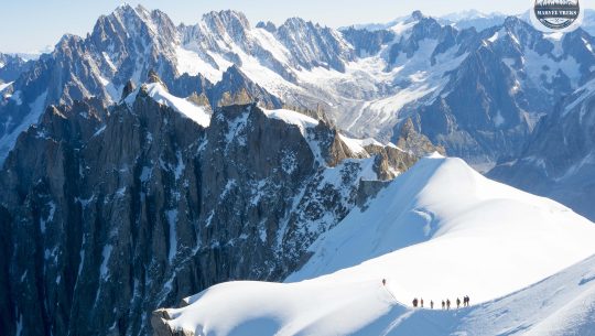
- The Himlung Himal expedition reaches the 7,126-meter summit of Himlung Himal safely and methodically.
- Acclimatization is built through two structured rotations before the summit push.
- The route enters the remote Nar–Phu Valley, far from crowded trekking corridors.
- Base Camp is established at a strategic altitude of 4,850 meters.
- Summit decisions follow strict weather window and turnaround protocols.
- Descent safety is prioritized more than summit celebration at all times.
- The itinerary avoids flights and relies on overland logistics for reliability.
- Recovery and consolidation days are built directly into the summit timeline.
- Professional guides manage pacing, health checks, and rope team discipline.
- The expedition concludes with a structured debriefing and responsible closure in Kathmandu.
Himlung Himal Expedition Overview
For climbers across the globe, Himlung Himal means something deeper. Hidden inside the Nar Phu Valley at 7,126 meters, it remains one of Nepal’s most remote peaks. And, unlike the world-famous Everest, this expedition offers real solitude that every mountaineer craves. However, what many people don’t realize is that this mountain is relatively young. Its first successful ascent was only recorded on October 27, 1983. But even with such a recent history, it inspires modern climbers through its remote setting, clean climbing lines, and the feeling of stepping onto a peak few have ever touched.
In fact, only 77 to 90 climbers make a successful ascent each autumn. And every climber begins the journey the same way: a 7 to 9 hour drive to Bulbule, then a calm, steady ascent toward Koto at 2,600 m. Besides that, there are several other reasons why every mountaineer should choose Himlung Himal over other peaks.
Why Himlung Himal?
Expedition campaigns are never easy, but compared to popular peaks like Everest or Annapurna I, Himlung offers a far more approachable ascent. With a proven success rate of around 75-90%, this gentle mountain can actually serve as a transition for people from peak climbing to an expedition.
Furthermore, the terrain strengthens this trust. The usual route holds steady at 30 to 35 degree ice slopes, with no rock climbing sections and almost no avalanche exposure along the northwest ridge. Additionally, fixed ropes cover the steepest 400 meters above 6,380 m, meaning climbers focus on endurance rather than extreme technical fear.
But the best part is how stable the conditions remain. For all the 50 to 90 climbers that attempt the ascent, spring and autumn offer predictable windows, with base camp temperatures rising to 15 to 20 degrees Celsius and summit temperatures dropping to -15 to -25 degrees Celsius, which ultimately gives climbers a clear framework for preparation. So, for anyone stepping toward 8,000-meter ambitions, best mountains to climb in Nepal include peaks like this that build confidence exactly where it matters most. With that being said, now let us tell you what the whole journey actually looks like.
Himlung Himal Expedition Overview
The whole journey actually starts from the moment you land in Kathmandu at 1,400 m, with 30 days of focused movement towards the Himalayas. Within four weeks, climbers move steadily from familiar city environments to remote alpine valleys that have demanding glacier routes. In fact, even before reaching the base camp, you have to cross the famous settlements like Koto at 2,600 m, Meta at 3,560 m, and Phu at 4,250 m. This trek before the climb lasts till Day 8 or 9, with each trekking day lasting for 5 to 8 hours.
Sounds demanding? Yes. But this approach does help in the acclimatization process.
From there, the route follows a structured ascent from the 4,900 m base camp to the 7,126 m summit, with Camp I at 5,450 m, Camp II at 6,000 m, and an optional Camp III set higher along the northwest ridge.
Since the vertical gain from base camp to the summit is roughly 2,226 m, it demands 10 to 14 days of continuous climbing.
Talking about the summit days, they often start in the dark and take about 6 to 8 hours to reach the top. After spending 15 to 20 minutes at the top, we have to descend back to our camp, which takes a few more hours. Besides patience and strength, the successful ascent also wholly depends up the seasons that you choose. If you ask us, late April to early May or October is the perfect time to plan this expedition, as during these time the whole valley gets little more hours of daylight and the weather is also suitable for climbing.
| Day | Itinerary | Altitude | Duration |
|---|---|---|---|
| 1 | Arrival in Kathmandu | 1,345 m | 1 hrs |
| 2 | Kathmandu → Besisahar (Drive) | 640 m | 6–7 hrs |
| 3 | Besisahar → Koto (Trek) | 1,700 m | 6–7 hrs |
| 4 | Koto → Meta | 3,560 m | 6–7 hrs |
| 5 | Meta → Chyaku | 3,800 m | 4–5 hrs |
| 6 | Chyaku → Kyang | 3,840 m | 3–4 hrs |
| 7 | Kyang → Phu Gaon | 4,080 m | 4 hrs |
| 8 | Phu Gaon → Himlung Base Camp | 4,900 m | 5–6 hrs |
| 9 | Acclimatization at Base Camp | 4,900 m | 1–2 hrs |
| 10 | Acclimatization & Puja Ceremony | 4,900 m | 1–2 hrs |
| 11 | Training & preparation at Base Camp | 4,900 m | 1–2 hrs |
| 12 | Base Camp → Camp I → Return to Base Camp | 5,500 m | 4 hrs |
| 13 | Camp I → Camp II → Return to Base Camp | 6,000 m | 4 hrs |
| 14 | Camp II → Camp III → Return / Rotation | 6,400 m | 4 hrs |
| 15 | Camp I / II rotation | 6,000 m | 3–4 hrs |
| 16 | Rest / Weather Buffer | 4,900 m | - |
| 17 | Pre-summit preparation at Base Camp | 4,900 m | 1–2 hrs |
| 18 | Base Camp → Camp II / Camp III | 6,400 m | 4–5 hrs |
| 19 | Summit Push Preparation | 6,400 m | 1–2 hrs |
| 20 | Summit Day → Descend to Camp III / II | 8,163 m | 12–14 hrs |
| 21 | Descend to Base Camp | 4,900 m | 5–6 hrs |
| 22 | Base Camp → Phu Gaon → Meta → Koto → Besisahar | 640–4,900 m | 8–9 hrs |
| 23 | Besisahar → Kathmandu (Drive) | 1,345 m | 6–7 hrs |
| 24 | Fly back home | 1,345 m | 1 hrs |
- Private Airport–Hotel–Airport transfers by vehicle (pick-up & drop).
- 4 nights accommodation in a 5-star hotel in Kathmandu on single room, bed & breakfast basis.
- One welcome dinner at a tourist-standard restaurant in Kathmandu with office staff.
- Assistance with cargo clearance at Nepal Customs (clearance fees charged separately).
- Government expedition royalty and Himlung Himal climbing permit.
- Conservation Area permits and all applicable National Park fees.
- Nar–Phu Restricted Area permit fee.
- One government-appointed Liaison Officer (LO) including salary, food, accommodation, insurance, and full equipment.
- Stool shipment and garbage deposit fees as required by the Government of Nepal.
- Medical and emergency rescue insurance for all Nepalese trekking and expedition staff.
- Trekking and expedition route map.
- One expedition duffle bag per member (Seven Summit Treks branded).
- Ground transportation for members from Kathmandu to Besisahar to Koto by tourist jeep.
- Return ground transportation from Koto to Besisahar to Kathmandu by private jeep as per itinerary.
- Transportation of all expedition gear and supplies from Kathmandu to Koto by jeep and from Koto to Base Camp by porters or mules, including return to Kathmandu.
- Transportation methods subject to change depending on road and trail conditions.
- Up to 60 kg of personal baggage per member carried by porters or mules during the trek.
- Three meals per day during the trek (breakfast, lunch, dinner) including tea, coffee, and hot water.
- Lodge or tea-house accommodation during the trek on a sharing basis.
- Hygienic meals throughout the trekking period.
- Full board meals at Base Camp including breakfast, lunch, dinner, tea, coffee, juice, and soft drinks.
- High-quality Base Camp meals with fresh vegetables, meat, fruits, and juices supplied via helicopter rotations.
- Personal comfortable box tent for each member at Base Camp.
- Fully equipped Base Camp including dining, kitchen, toilet, and shower tents.
- Separate accommodation tents for members and expedition staff at Base Camp.
- Porters for all members from Koto to Base Camp and return to Koto.
- Complete camping arrangements during the trek where required.
- Experienced Base Camp cook and kitchen helpers.
- All salaries, food, clothing, insurance, and equipment for Nepalese staff and porters.
- Private Base Camp tent per member (4-person tent used for single occupancy).
- Foam mattress and pillow at Base Camp.
- Dining tent, kitchen tent, staff tents, storage tent, communication tent, toilet tent, and shower tent.
- Tables, chairs, and all necessary kitchen equipment at Base Camp.
- Heaters in dining tents and essential Base Camp tents.
- Solar panels and generator for lighting, charging batteries, and electronic devices.
- Training at Base Camp on oxygen use, mask and regulator handling, and basic ice-climbing techniques by Sherpa guides.
- One government-licensed, veteran high-altitude climbing Sherpa per member (1:1 ratio) from Base Camp to summit including acclimatization rotations.
- Sherpa assistance for carrying climbing gear to high camps.
- Salary, food, insurance, clothing, and equipment for climbing Sherpas.
- Carry bonus and route-fixing bonus for Sherpas.
- Backup oxygen cylinder with mask and regulator available at Base Camp (usage charged separately).
- High-altitude tents at higher camps on a shared basis (two members per tent).
- EPI gas, stove sets, and high-altitude cooking equipment for higher camps.
- High-altitude meals for members, Sherpas, and support staff.
- Group climbing equipment including fixed ropes, dynamic ropes, anchors, and related safety gear.
- Route-fixing team of experienced Sherpas for opening and maintaining the climbing route.
- Satellite phone carried by Sherpa for emergency communication (calls charged separately).
- Walkie-talkies for communication between Base Camp and high camps.
- Walkie-talkie permits for all members and staff.
- Regular professional weather forecasts during the expedition period.
- Comprehensive medical kit for members and staff.
- Official Himlung Himal summit certificate issued by the Ministry of Culture, Tourism & Civil Aviation (MoCTCA).
- International airfare to and from Kathmandu.
- Nepal visa fee (USD 125 for 90 days).
- Lunch and dinner in Kathmandu.
- Meals in case of early return from trek or expedition.
- Additional hotel nights in Kathmandu due to early arrival, late departure, weather delays, or expedition changes.
- Mandatory personal travel and high-altitude insurance covering rescue, medical treatment, trip cancellation or interruption, air evacuation, and repatriation.
- Personal expenses including telephone calls, internet, laundry, hot showers, snacks, alcohol, and soft drinks.
- Personal climbing gear including clothing, boots, down suit, backpack, personal medical kit, and technical equipment.
- Personal toiletries such as soap, shampoo, toothpaste, tissues, and similar items.
- Filming, drone, or special camera permits.
- Wi-Fi or internet services during the trek or expedition.
- Minimum USD 800 summit bonus for climbing Sherpa.
- Tips for staff (recommended: USD 200 per porter and minimum USD 400 for Base Camp and high-camp staff).
- Any services not specifically mentioned in the “Cost Includes” section.
Detailed Itinerary
Day 1: Arrival in Kathmandu (1,400 m)
Trek Distance :
Airport transfer only (5 to 7 km)
Highest Altitude :
1,400 m
Trek Duration :
1-2 hrs (arrival + transfer)
Meals :
Breakfast / Dinner
After long international flights, Day 1 is simply about landing, breathing, and letting your body slow down.
You arrive at Tribhuvan International Airport, meet the team, and get a transfer to your hotel in Thamel.
After check-in, a hot shower, and gear re-organization, you can take a short walk for money exchange or last-minute shopping, then return early to rest, hydrate well, and shake off jet lag before the journey really begins.
Day 2: Briefings, Permits, and Final Gear Check
Trek Distance :
Local movement only
Highest Altitude :
1,400 m
Trek Duration :
Full day (briefings & prep)
Meals :
Breakfast / Dinner
You stay in Kathmandu today, but this is when the expedition quietly becomes real.
After having a hearty breakfast, you meet your lead guide for a detailed briefing on the Himlung route, acclimatization plan, and emergency protocols.
Then, the office team finalizes climbing permits and Nar-Phu special permits while you double-check boots, down layers, harness, and rental items in Thamel.
In the evening, a group dinner and final packing session set the tone and built trust before you leave the city.
Day 3: Drive from Kathmandu to Besi Sahar (760 m)
Trek Distance :
170 km
Highest Altitude :
760 m (Besi Sahar)
Trek Duration :
6 to 8 hrs drive
Meals :
Breakfast / Lunch / Dinner
Day 3 moves you out of the capital and into the Marsyangdi river corridor.
A private Jeep leaves Kathmandu after breakfast and follows the Prithvi Highway via Naubise and Malekhu before turning north at Dumre.
You cover roughly 170 km in 6 to 8 hours, with a simple highway lunch break on the way. By late afternoon, you roll into Besi Sahar (760 m), the opening town of Lamjung.
Then, you will check into a basic lodge and repack loads for tomorrow’s rougher mountain road.
Day 4: Off-Road Jeep to Koto (2,600 m)
Trek Distance :
80 km
Highest Altitude :
2,600 m
Trek Duration :
5 to 6 hrs drive
Meals :
Breakfast / Lunch / Dinner
This is a shorter distance but a serious altitude jump.
From Besi Sahar, you board a high-clearance 4WD and follow the jeep road through Syange, Jagat, Tal, Chamje, Dharapani, and Timang to Koto.
During the rough drive, you will cover 70 to 80 km of narrow, rocky mountain track, which takes around 5 to 6 hours with quick tea or lunch stops.
By mid-afternoon you reach Koto (about 2,600 m), the Nar-Phu trailhead, settle into a teahouse, and let your body adjust to its first real taste of Himalayan air.
Day 5: Trek from Koto to Meta (Nar Khola Gorge Section)
Trek Distance :
15 km
Highest Altitude :
3,625 m
Trek Duration :
6 to 7 hrs
Meals :
Breakfast / Lunch / Dinner
Day 5 is your first real mountain day as you leave Koto (2,600 m) and enter the restricted Nar-Phu Valley via the Nar Khola gorge.
You follow the forested Nar Khola section of the NartoPhu trail past Dharmasala and then climb hard onto the open plateau of Meta.
On this day, there will be 14.5 to 15 km of trekking, with about 6 to 7 hours on the trail.
Regarding elevation gain, it will be around 960 to 1,025 m, with the highest point at Meta at 3,560 to 3,625 m.
Day 6: Trek from Meta to Phu Gaon
Trek Distance :
16.5 km
Highest Altitude :
4,250 m
Trek Duration :
6 to 7 hrs trek
Meals :
Breakfast / Lunch / Dinner
Today, you move deeper into the high, empty valley that leads toward Tibet. From Meta (3,560 to 3,625 m), you follow the Chyaku-Kyang-Phu Khola section of the Nar-Phu route, crossing abandoned Khampa settlements before dropping briefly and then you move into the dramatic Phu Khola gorge.
By the end of a day, you cover 16 to 16.5 km in about 6 to 7 hours, gaining a net 520 to 690 m, with the highest point around 4,080 to 4,250 m at Phu Gaon.
Day 7: Acclimatization Day in Phu (Tashi Lhakhang Circuit)
Trek Distance :
8 km (side hike)
Highest Altitude :
4,500 m
Trek Duration :
4 to 5 hrs hike
Meals :
Breakfast / Lunch / Dinner
Day 7 is “active rest” designed purely for acclimatization above 4,000 m. You sleep at Phu Gaon (4,080 to 4,250 m) and take a short hike to the Tashi Lhakhang Monastery and hillside viewpoint circuit. This side hike is usually 6 to 8 km round trip over 4 to 5 hours, with 250 to 350 m of net ascent to high points around 4,400 to 4,500 m.
However, hiking in this region feels lighter without a full pack, but the thin air makes every step count for your Himlung summit chances.
By climbing high and returning to sleep low in Phu, you give your body the adaptation it needs before pushing toward Base Camp.
Day 8: Trek From Phu Gaon to Himlung Base Camp
Trek Distance :
9 km
Highest Altitude :
4,900 m
Trek Duration :
4 to 5 hrs
Meals :
Breakfast / Lunch / Dinner
This is the day you leave village trails and step into true expedition terrain.
From Phu Gaon (4,080 to 4,250 m) you follow the Phu-Pangir Glacier approach route over barren moraine and a slow, technical boulder field on the glacier’s surface before climbing the right-bank moraine to camp.
You’ll trek 8 to 9 km in about 4 to 5 hours, with a net elevation gain of 600 to 820 m, reaching Himlung Base Camp at roughly 4,850 to 4,900 m, the highest point for this phase. By midday you’re settling into tents on a grassy shelf above the Pangir Glacier, officially transitioning from Nar-Phu trekking team to Himlung Himal climbing expedition.
Day 9: Rest, Medical Checks & Acclimatization at Himlung Base Camp
Trek Distance :
3 km (optional walk)
Highest Altitude :
5,050 m
Trek Duration :
1.5 hrs (optional)
Meals :
Breakfast / Lunch / Dinner
After the demanding approach, Day 9 is a full Base Camp (4,850 to 4,900 m) reset day. You stay within camp, with an optional acclimatization walk of about 2 to 3 km on the nearby moraine, gaining roughly 100 to 200 m to a viewpoint around 4,950 to 5,050 m. And then you return to sleep back at Base Camp (net elevation change 0 m, 1 to 1.5 hours of easy walking).
Most of the day is about organization and safety: tent setup, gear sorting, and a full medical check using SpO₂, heart rate, and Lake Louise AMS scoring to see how your body is reacting to 4,800 m+. Guides also inspect boots, crampons, harnesses, helmets, ropes, and communal hardware so that every piece is ready before rotations begin. By evening, you’ve walked gently, hydrated well, and mentally accepted that this glacier basin is now your home for a few days.
Day 10: Puja Ceremony & Glacier Technical Training at Himlung Base Camp
Trek Distance :
4 km (training zone)
Highest Altitude :
5,050 m
Trek Duration :
4 hrs
Meals :
Breakfast / Lunch / Dinner
Day 10 blends Sherpa tradition and hard skills before you touch higher camps. In the morning, you join the puja ceremony at Base Camp (4,850 m), where prayer flags are raised, juniper smoke drifts over the tents, and all ice axes, crampons, and ropes are blessed for safe passage on Himlung’s Northwest Ridge route.
After breakfast, you move to a nearby glacier and moraine training zone above Pangir Glacier, covering about 3 to 4 km round trip, gaining up to 200 m to roughly 5,050 m and then descending back to camp (3 to 4 hours total field time). Here you practice fixed-rope climbing, crampon and front-point technique on 30 to 40 degree slopes, rope-team travel, and basic crevasse awareness, under close guide supervision. By the time you coil ropes back at Base Camp that afternoon, you’re no longer just trekkers at 4,850 m; rather, you’re a rope team ready for the first real rotation.
Day 11: Climb from Base Camp to Camp 1 (First Rotation Begins)
Trek Distance :
5 km
Highest Altitude :
5,450 m (Camp 1)
Trek Duration :
5 to 6 hrs
Meals :
Breakfast / Lunch / Dinner
Day 11 is your first true climbing day above Himlung Base Camp (4,850 m), following the Northwest Ridge approach over the moraine above Pangir Glacier. You climb about 4 to 5 km in 5 to 6 hours, gaining roughly 600 m to reach Camp 1 at around 5,450 m.
The route begins on loose moraine and boulder fields, then moves onto easy snow slopes of 20 to 30 degrees, with fixed lines on any steeper sections. Here, the goal is not speed but adaptation: you travel in rope teams, practice pressure breathing, drink steadily, and then sleep high for the first time at 5,450 m, accepting light headache and restless sleep as part of the acclimatization process.
Day 12: Climb from Camp 1 to Camp 2 (6,000 m) and Back to Base Camp
Trek Distance :
10 to 12 km (up & down)
Highest Altitude :
6,000 m (Camp 2)
Trek Duration :
10 to 12 hrs
Meals :
Breakfast / Lunch / Dinner
Day 12 follows the classic “climb high, sleep low” strategy on the Himlung Northwest Ridge route. From Camp 1 (5,450 m) you climb about 3 to 4 km in 4 to 5 hours to reach Camp 2 at roughly 6,000 m, gaining around 550 m on snow and ice slopes of 30 to 40° with sustained crampon work and fixed-rope travel.
After 30 to 45 minutes of rest, snacks, and short movement around Camp 2 to let the body really feel 6,000 m, you reverse the route all the way back to Base Camp (4,850 m), descending about 7 to 8 km in 6 to 7 hours and losing roughly 1,150 m of elevation. It’s a long, tiring day, but physiologically powerful: your body gets a sharp hypoxic stimulus at 6,000 m, then recovers overnight in the thicker air of Base Camp, which is exactly what prepares you for a 7,000 m summit.
Day 13: Base Camp Recovery & Acclimatization Consolidation
Trek Distance :
3 km (optional)
Highest Altitude :
5,050 m
Trek Duration :
1 to 2 hrs (optional)
Meals :
Breakfast / Lunch / Dinner
Day 13 is a full recovery day at Base Camp (4,850 m) with only an optional 2 to 3 km acclimatization walk gaining 100 to 200 m on nearby moraine. Most energy goes into sleep, food, and hydration, letting muscles recover from the long descent and giving your body time to build red blood cells after touching 6,000 m. Guides repeat quick medical checks, you reorganize gear for the second rotation, and by evening, you usually breathe a little easier, eat a little better, and know much more clearly how your body behaves above 5,000 m.
Day 14: Base Camp to Camp 1 (Second Rotation Begins)
Trek Distance :
5 km
Highest Altitude :
5,450 m
Trek Duration :
5 to 6 hrs
Meals :
Breakfast / Lunch / Dinner
You leave Base Camp at 4,850 m, knowing this path already, and that familiarity itself makes the second rotation feel lighter. Over 5 to 6 hours, you gain about 600 m back to Camp 1 at 5,450 m, but this time your breathing is more controlled, your head feels clearer, and the effort feels slightly less brutal than on Day 11.
The real goal today is not distance but repetition: giving your body a second full night at 5,450 m so the earlier adaptation sticks. As you settle into your tent, you usually notice better sleep, fewer headaches, and less anxiety about the altitude, all signs that acclimatization is truly working.
Day 15: Camp 1 to Camp 2 (First Night at 6,000 m)
Trek Distance :
4 km
Highest Altitude :
6,000 m
Trek Duration :
4 to 5 hrs
Meals :
Breakfast / Lunch / Dinner
Day 15 is when the rotation turns serious from an altitude point of view. You climb from 5,450 m to about 6,000 m and move your sleeping altitude up by another 550 m, crossing the psychological and physiological line into “extreme altitude”.
The day itself is shorter in distance than the later descent days, but every step feels heavier because there is simply less oxygen in every breath.
However, don’t worry, there is a strategy, it is brutal yet straightforward, which is to expose your body to a full night at 6,000 m, knowing sleep will be poor, appetite will drop, and dreams may turn strange. That controlled stress is exactly what triggers a big jump in red blood cell production and high-altitude fitness before summit week.
Day 16: Camp 2 to Camp 3 (Highest Sleeping Altitude)
Trek Distance :
3 km
Highest Altitude :
6,350 m (Camp 3)
Trek Duration :
3 to 4 hrs
Meals :
Breakfast / Lunch / Dinner
By Day 16, your legs are tired, your sleep debt is real, and yet you still push from Camp 2 (6,000 m) up to Camp 3 at around 6,350 m, which apparently becomes your highest sleeping point of the expedition.
The vertical gain is “only” about 350 m, but at this height, that feels like an entire mountain inside the mountain. This is not about building more strength; it is about teaching your body to function close to 6,400 m, only a few hundred vertical meters below Himlung’s summit.
Energy output is high, but time on the move is relatively short, so you can spend the rest of the day doing the real work: resting, hydrating, and letting your system adapt to the thinnest air you’ll sleep in before summit push.
Day 17: Camp 3 to Base Camp
Trek Distance :
10 km
Highest Altitude :
6,350 m
Trek Duration :
8 to 10 hrs descent
Meals :
Breakfast / Lunch / Dinner
Day 17 is a full altitude reset day. You drop from Camp 3 at 6,350 m all the way back to Base Camp at 4,850 m, usually over 8 to 10 hours of steady descent via Camps 2 and 1. Physically, it’s demanding on knees and quads, but every meter you lose gives you more oxygen, clearer thinking, and a calmer heartbeat.
From an acclimatization view, this is where the second rotation pays off: you’ve slept high three nights in a row, touched 6,350 m, and then returned to a level where you can finally sleep deep, eat properly, and recover. By the time you crawl into your Base Camp tent that night, you’re no longer just “trying Himlung,” instead, you’re genuinely summit-capable.
Day 18: Controlled Recovery & Medical Consolidation
Trek Distance :
N/A
Highest Altitude :
4,850 m
Trek Duration :
Rest day
Meals :
Breakfast / Lunch / Dinner
Day 18 is kept deliberately quiet. This is because after days above 6,000 to 6,350 m, you finally let your body catch up at 4,850 m.
Most of the day is spent on controlled recovery, which means long sleep, high-calorie meals, and 4 to 5 litres of fluids to reverse the deficits from Camp 2 and Camp 3.
Furthermore, this is also the day when guides run complete medical and symptom checks, grouping climbers into clear categories for summit readiness.
And by evening, the priority is simply to recover deeply, so no one is gambling with their health later.
Day 19: Flexible Buffer Day & Team Readiness Review
Trek Distance :
N/A
Highest Altitude :
4,850 m
Trek Duration :
Buffer Day
Meals :
Breakfast / Lunch / Dinner
Day 19 is deliberately kept as the buffer day, not a bonus hiking day. How it is used depends on two things: weather charts and vital signs.
If forecasts are unclear, the team stays patient at Base Camp, focusing on weather-window monitoring rather than pushing higher too soon.
Besides that, if recovery is still incomplete, it becomes a second rest day; if everyone is stable, only a very light walk is considered.
By night, guides finalize a team readiness review, quietly confirming who will and won’t enter the summit plan.
Day 20: Final Assessments & Summit Decision Day
Highest Altitude :
4,850 m
Trek Duration :
4 to 6 hrs (checks & prep)
Meals :
Breakfast / Lunch / Dinner
Day 20 is calm but structured, which means no extra altitude, just 4to6 focused hours of checks, packing, and briefings at 4,850 m.
Forecasts are compared in the morning and evening, and the lead guide follows a clear summit decision protocol. The team will either give a green light, a short delay, or a stand-down.
Then, each climber passes a last medical and readiness check and then organizes a simple, efficient load for the days ahead.
The rest of the time is intentionally quiet: eating, hydrating, resting, and arriving at bed knowing the plan is careful, not rushed.
Day 21: Base Camp to Camp 2 (Final Summit Push Begins)
Trek Distance :
7 km
Highest Altitude :
6,000 m
Trek Duration :
6 to 7 hrs
Meals :
Breakfast / Lunch / Dinner
After three quiet days at 4,850 m, Day 21 is the first deliberate move back into thin air. You leave Base Camp after an early breakfast and walk a familiar line through moraine and snow, gaining roughly 1,150 m to reach Camp 2 at 6,000 m.
Because you’ve already slept here during the second rotation, the focus is not “can my body handle this height?” but “can I reach it calmly, with enough energy left for tomorrow?”
Guides keep the pace steady, breaks short, and hydration frequent, so no one “wins the day” and loses the summit.
By mid-afternoon, you’re back inside a routine you already know: simple hot meal, gear checked, layers laid out, and an early lie-down. Before you close your eyes, the team walks through a clear plan for the night: wake around midnight, move in rope teams, and turn back if the schedule or health markers fall outside agreed limits.
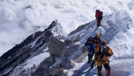
Day 22 Summit Day of Himlung Himal (7,126 m) and descend back to Camp 2
Trek Distance :
12 km
Highest Altitude :
7,126 m (Summit)
Trek Duration :
12 to 16 hrs
Meals :
Breakfast / Lunch / Dinner
Summit day starts quietly, not dramatically. Around 12:00 to 1:00 a.m., you step out from Camp 2 (6,000 m) under a headlamp, moving in small rope teams toward Camp 3 at 6,350 m. The route is already known from your acclimatization rotation; the difference now is discipline: shorter pauses, stricter pace, and constant checks on breathing, balance, and clarity.
A brief stop at Camp 3 is just long enough for water, a quick calorie top-up, and a guide’s assessment. From here, the push toward the 7,126 m summit is managed almost like a long, controlled interval: slow, repeatable steps, short rests, and quiet monitoring of time. As dawn comes in, you move onto the upper slopes and ridge, where the team leans on techniques already practiced earlier in the expedition rather than trying anything new on the biggest day.
Near the top, decisions stay data-driven, not emotional. Guides track progress against the agreed turnaround time, individual responses to altitude, and the changing sky. If all three are within safe margins, the rope teams step onto the summit for a short, respectful stay, which usually lasts 20 to 30 minutes. Photos, a few flags, and a moment of calm are enough; no one is encouraged to “stretch the window” for longer celebrations.
The descent is treated as the real priority of the day. You retrace the same line down to Camp 3 and then back to Camp 2, with deliberate breaks for fluids and food. Tired climbers are placed closer to guides, and any sign of poor coordination or confusion is treated as a reason to slow down, not push on. By mid-afternoon, the goal is simple and non-negotiable: everyone back inside Camp 2, re-hydrated, eating, and able to rest at a known sleeping altitude.
Day 23 Descent From Camp 2 to Base Camp
Trek Distance :
8 km
Highest Altitude :
6,000 m
Trek Duration :
7 to 8 hrs
Meals :
Breakfast / Lunch / Dinner
Day 23 is about leaving the high camps cleanly. After a full breakfast at 6,000 m, you descend in stages via Camp 1 (5,450 m) back to Base Camp at 4,850 m, taking 7 to 8 hours in total. The mood is lighter, but the guiding style does not relax: spacing on the descent, pace control, and regular checks on footing are all enforced to avoid “tired-legs mistakes” on familiar ground.
By late afternoon, you step back onto the rocks and tents of Base Camp with the summit behind you and the climbing phase officially complete. The emphasis now shifts to recovery and debrief: re-hydration, medical checks, a clear summary of what went well, and quiet appreciation for the fact that the team summited and descended within the planned safety margins, exactly as a mature Himlung itinerary should.
Day 24: Descent From Base Camp to Phu Gaon
Trek Distance :
7 km
Highest Altitude :
4,850 m
Trek Duration :
3 to 4 hrs
Meals :
Breakfast / Lunch / Dinner
The first day out of Base Camp feels quieter, but still structured. You follow the same line down from around 4,850 m to Phu Gaon at roughly 4,100 m, taking 3 to 4 hours over glacier moraine and then easier valley paths.
This is a gradual descent day, focused on getting the team back to permanent lodges, hot kitchen facilities, and more stable ground. By evening, everyone is sleeping at a lower, safer height, and the expedition has clearly moved from “climbing phase” into “controlled recovery.”
Day 25 Descent From Phu Gaon to Meta
Trek Distance :
16 km
Highest Altitude :
4,100 m
Trek Duration :
6 to 8 hrs
Meals :
Breakfast / Lunch / Dinner
With the summit behind you, Day 25 is about consistent, careful walking rather than pushing limits. You descend from about 4,100 m to Meta at around 3,600 m over 6 to 8 hours, using the same main trail you followed on the approach.
The terrain gradually feels easier on the lungs and joints, but the pacing stays professional: steady speed, regular hydration breaks, and simple check-ins on knees, ankles, and overall energy. This is another gradual descent day, trading altitude for comfort while keeping the group moving as one unit.
Day 26: Descent from Meta to Koto
Trek Distance :
15 km
Highest Altitude :
3,600 m
Trek Duration :
6 to 8 hrs
Meals :
Breakfast / Lunch / Dinner
Day 26 is the last full trekking day of the expedition. You drop from roughly 3,600 m to the roadhead at Koto, around 2,600 m, over 6 to 8 hours on a long downhill trail. It is still a working day for the body: continuous focus on careful foot placement, managing impact on tired legs, and keeping rope or group spacing on narrower sections.
By reaching Koto, the team closes the walking chapter and transitions to road-based logistics, with the main climbing and trekking risks now behind them.
Day 27: Jeep Drive From Koto to Besi Sahar
Trek Distance :
70 to 80 km
Highest Altitude :
2,600 m
Trek Duration :
5 to 7 hrs drive
Meals :
Breakfast / Lunch / Dinner
From Koto, the expedition switches fully to vehicles. A 5 to 7 hour 4WD road transfer carries you down from about 2,600 m to Besi Sahar at roughly 760 m, following the rough jeep track through the Marsyangdi corridor. The team travels together, with guides monitoring how everyone is coping with the long drive and rapid altitude loss. The aim of the day is simple: a safe road transfer back to district headquarters, with all key equipment, paperwork, and people accounted for.
Day 28: Drive from Besi Sahar to Pokhara
Trek Distance :
110 km
Highest Altitude :
830 m
Trek Duration :
3 to 4 hrs
Meals :
Breakfast / Lunch / Dinner
Day 28 is a shorter but important logistical link. You continue by road from Besi Sahar (760 m) to Pokhara (820 to 830 m) in around 3to4 hours, depending on traffic and road conditions. On arrival, the expedition reconnects with full urban services: reliable power, laundry, and easier medical access if anyone needs follow-up. The focus here is physical recovery and logistics completion, not sightseeing.
Day 29: Drive from Pokhara to Kathmandu (Highway Return & Debrief)
Trek Distance :
200 km
Highest Altitude :
1,400 m
Trek Duration :
7 to 9 hrs
Meals :
Breakfast / Lunch / Dinner
Day 29 is the long highway day that brings the team back to the capital. You drive 7 to 9 hours from Pokhara (830 m) to Kathmandu (1,350 to 1,400 m), using the main Prithvi Highway. Once in the city, the expedition shifts into formal debrief and closure mode: leader feedback, summit-day review, performance notes, and structured thanks to guides and support staff.
Then, before you leave, we will organize a dinner to celebrate your summit formally.
Day 30: Departure from Kathmandu
Trek Distance :
Airport transfer only
Highest Altitude :
1,400 m
Trek Duration :
1 to 2 hrs
Meals :
Breakfast
The final day is quiet and practical. Equipment is dried, sorted, and packed; remaining documents (such as summit confirmations and permit copies) are distributed; and any last medical or recovery advice is shared. Ground departure logistics are then coordinated to bus parks or local transfer points, with international travel handled separately by each climber. By the end of Day 30, the Himlung Himal expedition is fully closed on paper, on the ground, and in a way that clearly prioritizes safety, accountability, and responsible exit from the mountain.
Avalanche Risks And Dangers During the Himlung Himal Expedition
By the time you commit to a whole expedition, you know the risks of AMS. What’s often underestimated is that night temperatures on Himlung Himal can drop to –15°C to –25°C, while oxygen levels fall to nearly half those at sea level.
This means even mild symptoms, such as a headache or slight loss of balance, can become serious. And god forbid, if anything like this happens on steeper slopes, then the consequences can be life-threatening.
This is precisely why we kept 2 to 3 acclimatization days in the itinerary, and why our climbers are required to inform guides of even small changes in how they feel.
Avalanche Risks During The Himlung Himal Expedition
While the avalanche danger in Himlung Himal is lower compared to other 7,000 m+ Himalayas, it is never zero. In fact, risk levels increase substantially after fresh snow or wind-loaded conditions on 30-degree+ slopes above the Pangri Glacier.
Historically, many avalanches occur between Camp I and Camp II, especially after a storm, as during that moment, wind-loaded side slopes can develop slab formations, threatening the safety of all the climbers.
For this reason alone, experienced teams typically delay progress by 24 to 48 hours after the heavy snowfall, even if the weather looks fine.
On the other hand, this mountain’s wider region has already shown how dangerous avalanche cycles can be. In November 2025, seven climbers were killed on Yalung Ri (5,630 m) and two others on Panbari Himal in the Manaslu region, all during the same period of unstable weather.
The saddest part is it happed just days apart in a neighboring region. These kinds of incidents remind us that even routes considered safer (like Himlung’s northwest ridge) are still part of a dynamic Himalayan avalanche system.
| Region / Area | Avalanche Risk Level & Notes |
| Himlung NW Ridge & Pangri Glacier | Low–Moderate: localized slab risk 5,600–6,000 m after fresh storms; generally ridge-safe |
| Yalung Ri & Panbari (Manaslu side) | High (documented): fatal avalanches in Nov 2025 during unstable autumn snowpack |
In the end, the safest climbers are the ones who treat every fresh storm, wind-loaded slope, and “perfect weather day” with equal respect and are willing to turn back long before the mountain forces the decision.
How Do We Keep You Safe In Himlung Himal?
As a leading expedition organizer in Nepal, we understand that there is a difference between simply going to 7,126 m and going there with a team trained to protect you at every step. Choosing the best expedition and trekking company in Nepal ensures that level of safety and expertise. That’s why our Himlung Himal expedition is led only by Sherpa guides with more than 15 years of climbing experience. Furthermore, each guide we assign has at least three successful Himlung climbs behind them.
This means when you clip into a fixed rope at 6,000 m, you are not just trusting the rope rather you’r also trusting the people who placed it there, checked it twice and have walked that same route multiple times.
Marvel Treks’ Safety Approach
Guess what, from the very first briefing in Kathmandu, our safety plan is already in motion.
We design your itinerary in such a way that there is no more than 300 to 500 m sleeping elevation gain per day, once you go above 3,000 m. As a matter of fact, for this specific campaign, we include 2 to 3 full acclimatization days at base camp.
Additionally, we use the climbing to the top, sleep at down strategy rotations between Camp I and Camp II, which keeps a check on body adjustment before the summit week really begins. And finally, when the climbing begins, we constantly measure your health.
Every day, our team checks SpO2 levels, resting heart rate, and basic Lake Louise symptoms, and if oxygen saturation drops below about 75–80% or your pulse stays above 100 bpm, we slow down or descend immediately.
At the same time, we keep reminding you to drink 4–5 litres of water per day and aim for roughly 5,000–8,000 kcal of food intake, because dehydration and low energy are often the first silent problems at altitude.
But wait, that’s not it, on the technical side, we install around 800–1,000 meters of fixed rope on the steeper 30 to 40 degree sections, with anchors spaced every 20–30 meters and checked by two separate guides before the team moves.
During the summit phase, our effective ratio is 1 climbing Sherpa for 1 climber, so no one is ever alone on exposed ground, and no decision, whether to push, pause, or turn back, is made without real-time weather data and a clear turnaround time, usually set around early afternoon.
And if something does go wrong, we don’t improvise; we execute. With satellite phones, radio contact between camps, pre-identified helicopter landing zones in the Nar-Phu Valley, and mandatory high-altitude insurance of at least USD 10,000 for evacuation, every serious incident has a predefined path: stabilize, descend, and extract.
Our goal is simple: your summit story should end not just with a height of 7,126 m, but with a safe return to Kathmandu and the quiet confidence that every risk was managed with care.
Training, Fitness, and Experience Required
Himlung looks friendly on paper, but it is still classified as AD(Alpine Difficile), and requires a 30-day expedition. This means this climb is ideal for people who already know how their bodies behave above 5,000–6,000 m and are comfortable on snow and ice in crampons.
Furthermore, it is for those who are happy to follow a guide’s decision even when ego says “push”. If you have at least one, and ideally two, successful 6,000 m peaks behind you, Himlung feels like a logical next step instead of a gamble.
On the other hand, physically, you should be able to hike 6–8 hours with a 15–20 kg pack, repeat that for several days, and still think clearly when tired. A good pre-trip benchmark is being able to do a 20 km hike with 1,000–1,500 m ascent in a single day, plus regular cardio (running, cycling, stair climbing) 3–5 times a week. This level of fitness is essential for handling himalayan climbing logistics effectively in high-altitude expeditions.
You can also add basic strength work for legs and core, and at least some time practicing with crampons, an ice axe, and a rope team before you fly to Nepal.
Recommended Prior Climbs Before Himlung
| Peak / Objective | Altitude & Style | Why It Helps for Himlung |
| Mera Peak | 6,476 m, mostly non-technical | Tests pure altitude tolerance and long summit day |
| Island Peak | 6,189 m, glacier + headwall | Builds fixed-rope, crampon and ice-axe skills |
| Lobuche East | 6,119 m, steeper mixed terrain | Trains you for sustained effort on exposed slopes |
Who Should Not Attempt This Expedition (Yet)
| Profile | Why Waiting Is Safer |
| No prior 5,000–6,000 m experience | Unknown altitude response; very high AMS risk |
| Unwilling to train 3–4 months seriously | Fitness and skill gap becomes dangerous above 7,000 m |
Permits, Insurance and Regulations required for Himlung Himal Expedition
It’s easy to focus only on the summit at 7,126 m, but the truth is your Himlung expedition actually begins with paperwork in Kathmandu at 1,400 m. These permits, insurance papers, and regulations might feel bureaucratic, yet they are exactly what make a 25–30 day climb in a restricted border valley safe and legal.
And when everything is approved 3–7 days before you leave the city, the rest of the journey flows with less surprises.
Permits You Must Have
For Himlung, you need three main permits, all arranged through a licensed Nepali operator:
Himlung Himal Climbing Permit (DoT):
- Issued by the Department of Tourism in Kathmandu.
- Cost: USD 500 per foreign climber in spring and autumn; USD 125 in winter/summer.
Nar-Phu Restricted Area Permit (RAP):
- Required because the route passes a sensitive border valley.
- Cost: usually **USD 150–250 per person** for a 25–30 day itinerary.
- Rules: minimum 2 people and a registered guide; solo entry is not allowed.
Annapurna Conservation Area Permit (ACAP):
- Often needed as you pass through Koto and nearby ACAP zones.
- Cost: NPR 3,00 (about USD 23–25) for foreigners.
Insurance and Legal Safety
For a 7,126 m peak, travel insurance is not optional anymore; from 2025 onward, “no valid policy means no permit”. A proper Himlung policy should include:
- Altitude coverage to at least 7,500 m.
- USD 35,000–50,000 medical cover for AMS, HAPE, and HACE.
- USD 10,000–15,000 helicopter evacuation for Nar-Phu Valley.
- Accidental death/disability cover of USD 17,500–35,000.
- Dates that fully cover your 30-day expedition plus a few buffer days.
On top of this, a recent medical certificate (issued within 30 days of departure), fair-wage and insurance protection for Sherpas and porters, and a certified mountain guide are now written into Nepal’s updated 2025 regulations. Choosing an operator like us who respects all of this doesn’t just keep you legal; it keeps both you and your team genuinely safer all the way to Himlung’s summit and back.
Teams Required for a Himlung Himal Expedition
Climbing Himlung is not just “you and your guide” on a mountain; it requires a team equivalent to a small village.
This village usually ends up being 8–15 staff for 4–6 climbers, all with clear roles so you can focus on climbing instead of logistics.
Core High-Altitude Team
Lead Expedition Guide / Sirdar
- 15+ years’ experience, NMA/IFMGA certified, multiple Himlung or 7,000 m summits.
- Decides route, summit window, turnaround time and “no-go” calls.
Climbing Sherpa (1:1 or 1:2 ratio)
- Ideally, 1 Sherpa per climber on summit push.
- Fixes ropes, carries key gear, checks your health, and literally clips you into safety systems.
Assistant Sherpas / High-Altitude Porters
- Carry tents, fuel, food, ropes to higher camps.
- Help set up Camp I–III and support emergencies.
Base Camp & Support Team
- Base Camp Manager – runs daily schedule, communication, weather updates, inventory and hygiene.
- Cook + Kitchen Helper – provide 3 hot meals a day plus snacks, keeping you at 5,000–8,000 kcal intake.
- Liaison Officer (Government) – mandatory DoT representative who checks permits, environment rules and files final report.
- Trekking Porters (Approach & Exit) – carry duffel bags on the trek in and trek out, protecting both your back and your energy.
A good Himlung operator will show you this full team on paper before you book, so you know who is actually standing between you and a bad day at 7,000 meters.
Packing Lists For The Himlung Himal Expedition
Now that your team is sorted, let’s sort what you should pack during the Himlung Himal Expedition. Remember, smart packing can lead to a very comforting experience.
- Upper Body Layers – 3–4 moisture-wicking base layers (light + mid), 1–2 fleeces, 1 lightweight down jacket, 1 expedition down parka with hood, 1 waterproof/windproof shell.
- Lower Body Layers – 2–3 thermal bottoms, 1 trekking pant, 1 softshell or hardshell pant, optional down pants for high camps.
- Head & Face – warm beanie, balaclava, sun hat, 1–2 buffs/neck gaiters, glacier sunglasses (plus backup), high-SPF sunscreen, SPF lip balm.
- Hands – 1–2 liner gloves, 1 warm glove pair, 1 waterproof shell glove, 1 expedition summit mitten.
- Footwear – 1 pair double mountaineering boots, 1 pair trekking boots, 3–5 pairs trekking socks, 1–2 heavy socks, camp sandals/Crocs, optional insulated booties.
- Technical Climbing Gear – 12-point crampons, ice axe, climbing harness, helmet, 2–3 locking carabiners, belay/rappel device, ascender (jumar), 1–2 prusik slings, gaiters, trekking poles.
- Sleeping System – 1 expedition sleeping bag (-30°C to -40°C), liner, inflatable sleeping pad, eye mask and earplugs.
- Health & Meds – personal first-aid kit, blister care, painkillers, anti-nausea and anti-diarrheal meds, personal prescriptions, altitude meds (Diamox etc. as advised by your doctor), hand sanitizer, wet wipes, basic toiletries.
- Hydration & Eating – 2–3 one-liter bottles, 1 thermos, purification tablets, electrolyte/ORS sachets, personal mug/spoon.
- Electronics & Docs – headlamp + spare batteries, phone, power bank, charging cables, camera (optional), passport, insurance papers, permit copies, emergency contacts, some cash in USD/NPR.
- Personal Snacks – energy bars, nuts, dried fruit, chocolate, gels or glucose tablets for summit day.
Food And Accommodation During The Himlung Himal Expedition
From the first day of your arrival in Kathmandu, right till the day of your summit and return, we sort out all your food and accommodation needs.
Starting in Kathmandu, you will receive at least 3-star hotel accommodation with breakfast included. However, as you move higher, the choices become limited and transition from comfortable hotel rooms to family-owned tea house lodges and finally after Himlung Base Camp it shifts to classic camp tents.
Food That You Will Have During The Trek And Climb
On the approach trek, you eat in teahouses where the choices look something like this:
- Breakfast: porridge, roti, eggs, Tibetan bread, pancakes, tea/coffee.
- Lunch & dinner: dal bhat, soups, fried rice/noodles, momos, occasional pizza or pasta, always with a hot drink.
Then at Base Camp (around 4,900 m), a whole kitchen team cooks three proper meals a day plus snacks where you can expect to get:
- Breakfast: porridge, pancakes, eggs, roti, tea/coffee.
- Lunch & dinner: rice, pasta, noodles, vegetable curries, lentils, canned tuna/meat, soups.
- All day: biscuits, nuts, chocolate, dried fruit, energy bars, and unlimited boiled water for hydration.
However, things make a drastic turn above Base Camp. Due to limited choices, your food becomes lighter and more technical. During the climb you will get meals like these:
- Camps I–III: freeze-dried or ready-to-eat meals, noodles, soup packets, chocolate, nuts, energy, and protein bars.
- Water comes from melted snow, boiled and stored in thermoses, with electrolyte powders added.
- Portions are smaller, but calorie density is higher – lots of fat and simple carbs to keep you moving in thin air.
Note: Alcohol and fizzy drinks are normally avoided completely at altitude.
Accommodation During The Himlung Himal Climb
On the trek in, you sleep in basic but clean teahouse rooms, usually twin-share with shared toilets and paid hot showers.
From Base Camp upward, everything is tent-based:
- Base Camp: spacious 4-season sleeping tents (often one per climber), plus separate dining, kitchen, shower and toilet tents, solar power, and a heated dining tent.
- Camps I, II, and III: compact two-person expedition tents on carved-out snow or rock platforms, no dining tent, minimal comfort. You mostly eat, sleep, and wait inside the same small space, while the mountain and weather decide when you can move again.
Are You Ready For Himlung Himal?
Himlung Himal is not a mountain you rush, and this expedition is designed with that understanding. Over 30 disciplined days, your body adapts gradually, decisions follow weather and health data, not emotion, and every phase prioritizes safe movement over speed.
From structured acclimatization to conservative summit protocols and a measured road-based exit, this climb rewards patience and preparation. If you are comfortable with long timelines, controlled pacing, and professional decision-making at high altitude, Himlung offers a serious but achievable 7,000-meter objective. The question is not only about strength or skill, but about judgment, discipline, and respect for the mountain.
Error: Contact form not found.
Price W/O Addons: US$ per person
- Private Airport–Hotel–Airport transfers by vehicle (pick-up & drop).
- 4 nights accommodation in a 5-star hotel in Kathmandu on single room, bed & breakfast basis.
- One welcome dinner at a tourist-standard restaurant in Kathmandu with office staff.
- Assistance with cargo clearance at Nepal Customs (clearance fees charged separately).
- Government expedition royalty and Himlung Himal climbing permit.
- Conservation Area permits and all applicable National Park fees.
- Nar–Phu Restricted Area permit fee.
- One government-appointed Liaison Officer (LO) including salary, food, accommodation, insurance, and full equipment.
- Stool shipment and garbage deposit fees as required by the Government of Nepal.
- Medical and emergency rescue insurance for all Nepalese trekking and expedition staff.
- Trekking and expedition route map.
- One expedition duffle bag per member (Seven Summit Treks branded).
- Ground transportation for members from Kathmandu to Besisahar to Koto by tourist jeep.
- Return ground transportation from Koto to Besisahar to Kathmandu by private jeep as per itinerary.
- Transportation of all expedition gear and supplies from Kathmandu to Koto by jeep and from Koto to Base Camp by porters or mules, including return to Kathmandu.
- Transportation methods subject to change depending on road and trail conditions.
- Up to 60 kg of personal baggage per member carried by porters or mules during the trek.
- Three meals per day during the trek (breakfast, lunch, dinner) including tea, coffee, and hot water.
- Lodge or tea-house accommodation during the trek on a sharing basis.
- Hygienic meals throughout the trekking period.
- Full board meals at Base Camp including breakfast, lunch, dinner, tea, coffee, juice, and soft drinks.
- High-quality Base Camp meals with fresh vegetables, meat, fruits, and juices supplied via helicopter rotations.
- Personal comfortable box tent for each member at Base Camp.
- Fully equipped Base Camp including dining, kitchen, toilet, and shower tents.
- Separate accommodation tents for members and expedition staff at Base Camp.
- Porters for all members from Koto to Base Camp and return to Koto.
- Complete camping arrangements during the trek where required.
- Experienced Base Camp cook and kitchen helpers.
- All salaries, food, clothing, insurance, and equipment for Nepalese staff and porters.
- Private Base Camp tent per member (4-person tent used for single occupancy).
- Foam mattress and pillow at Base Camp.
- Dining tent, kitchen tent, staff tents, storage tent, communication tent, toilet tent, and shower tent.
- Tables, chairs, and all necessary kitchen equipment at Base Camp.
- Heaters in dining tents and essential Base Camp tents.
- Solar panels and generator for lighting, charging batteries, and electronic devices.
- Training at Base Camp on oxygen use, mask and regulator handling, and basic ice-climbing techniques by Sherpa guides.
- One government-licensed, veteran high-altitude climbing Sherpa per member (1:1 ratio) from Base Camp to summit including acclimatization rotations.
- Sherpa assistance for carrying climbing gear to high camps.
- Salary, food, insurance, clothing, and equipment for climbing Sherpas.
- Carry bonus and route-fixing bonus for Sherpas.
- Backup oxygen cylinder with mask and regulator available at Base Camp (usage charged separately).
- High-altitude tents at higher camps on a shared basis (two members per tent).
- EPI gas, stove sets, and high-altitude cooking equipment for higher camps.
- High-altitude meals for members, Sherpas, and support staff.
- Group climbing equipment including fixed ropes, dynamic ropes, anchors, and related safety gear.
- Route-fixing team of experienced Sherpas for opening and maintaining the climbing route.
- Satellite phone carried by Sherpa for emergency communication (calls charged separately).
- Walkie-talkies for communication between Base Camp and high camps.
- Walkie-talkie permits for all members and staff.
- Regular professional weather forecasts during the expedition period.
- Comprehensive medical kit for members and staff.
- Official Himlung Himal summit certificate issued by the Ministry of Culture, Tourism & Civil Aviation (MoCTCA).
- International airfare to and from Kathmandu.
- Nepal visa fee (USD 125 for 90 days).
- Lunch and dinner in Kathmandu.
- Meals in case of early return from trek or expedition.
- Additional hotel nights in Kathmandu due to early arrival, late departure, weather delays, or expedition changes.
- Mandatory personal travel and high-altitude insurance covering rescue, medical treatment, trip cancellation or interruption, air evacuation, and repatriation.
- Personal expenses including telephone calls, internet, laundry, hot showers, snacks, alcohol, and soft drinks.
- Personal climbing gear including clothing, boots, down suit, backpack, personal medical kit, and technical equipment.
- Personal toiletries such as soap, shampoo, toothpaste, tissues, and similar items.
- Filming, drone, or special camera permits.
- Wi-Fi or internet services during the trek or expedition.
- Minimum USD 800 summit bonus for climbing Sherpa.
- Tips for staff (recommended: USD 200 per porter and minimum USD 400 for Base Camp and high-camp staff).
- Any services not specifically mentioned in the “Cost Includes” section.
Departures & Availability of Himlung Himal Expedition
Dates of Trip
Group Discount Prices
Frequently Asked Questions
Traveler Reviews


from
$ /pax
speak to an Experts


We are featured on